IMAGES TAKEN NEAR TO
Charles Grinling Walk, LONDON, SE18 5BD
Introduction
This page details the photographs taken nearby to Charles Grinling Walk, SE18 5BD by members of the Geograph project.
The Geograph project started in 2005 with the aim of publishing, organising and preserving representative images for every square kilometre of Great Britain, Ireland and the Isle of Man.

There are currently over 7.5m images from over14,400 individuals and you can help contribute to the project by visiting https://www.geograph.org.uk
Image Map (Loading...)


Getting Data...Please wait
Leaflet Map data © OpenStreetMap
Images are licensed for reuse under creativecommons.org/licenses/by-sa/2.0
Notes
- Clicking on the map will re-center to the selected point.
- The higher the marker number, the further away the image location is from the centre of the postcode.
Image Listing (128 Images Found)
Images are licensed for reuse under creativecommons.org/licenses/by-sa/2.0
Image
Details
Distance
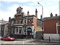
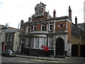
1
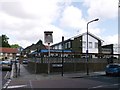
King George V, Public House, Woolwich
On the junction of Rectory Place and Kingman Street (on the right).
Image: © David Anstiss
Taken: 26 Aug 2012
0.09 miles
4
Calderwood Street, Woolwich
Seen from Monk Street.
Image: © Richard Vince
Taken: 14 May 2016
0.11 miles
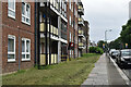
5
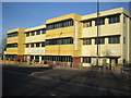
Woolwich: Ferryview Health Centre
This modular building is on the A205 John Wilson Street, and accommodates a seven-GP practice, along with community health services staff and a mental health team.
The Centre was designed and built by Yorkon Limited using an innovative modular building method. Sixty-six steel framed modules were manufactured in York, delivered by road and craned into position in just a few days, so minimising local disruption and reducing the time on site from 15 months to around 9 months. Yorkon's website is here http://www.yorkon.co.uk/
Image: © Nigel Cox
Taken: 31 Jan 2007
0.11 miles
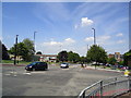
6
Former public house, Woolwich
Formerly known as the "Evening Star". The short length of road to the left of the pub is part of the original John Wilson Street, rebuilt as a dual carriageway just to the west (left of picture) to take traffic to the Woolwich Free Ferry round the town centre rather than through it.
Image: © Stacey Harris
Taken: 4 Jul 2011
0.12 miles
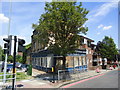
7
Woolwich Public Library
Grade II listed building, on Calderwood Road. Beside the Magistrates Court (on the right).
http://www.britishlistedbuildings.co.uk/en-493801-public-library-48-woolwich
Image: © David Anstiss
Taken: 21 Aug 2011
0.12 miles
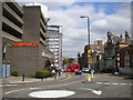
8
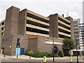
Woolwich Sainsbury's Supermarket
On the junction of Monk Street (on the left) and Calderwood Street (on the right).
Has a multi-storey car park above.
Image: © David Anstiss
Taken: 21 Aug 2011
0.12 miles
9
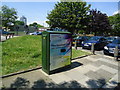
Openreach super-fast broadband cabinet, Woolwich
Image: © Stacey Harris
Taken: 4 Jul 2011
0.12 miles
10
Old library, Calderwood Street, Woolwich
Image: © Richard Vince
Taken: 14 May 2016
0.12 miles