IMAGES TAKEN NEAR TO
Howerd Way, LONDON, SE18 4PX
Introduction
This page details the photographs taken nearby to Howerd Way, SE18 4PX by members of the Geograph project.
The Geograph project started in 2005 with the aim of publishing, organising and preserving representative images for every square kilometre of Great Britain, Ireland and the Isle of Man.

There are currently over 7.5m images from over14,400 individuals and you can help contribute to the project by visiting https://www.geograph.org.uk
Image Map
Images are licensed for reuse under creativecommons.org/licenses/by-sa/2.0
Notes
- Clicking on the map will re-center to the selected point.
- The higher the marker number, the further away the image location is from the centre of the postcode.
Image Listing (107 Images Found)
Images are licensed for reuse under creativecommons.org/licenses/by-sa/2.0
Image
Details
Distance
1
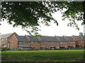
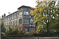
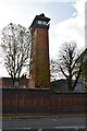
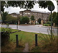
Housing on Howerd Way
Howerd Way is one of several streets of new housing built in the early 2000s on the site of the former Brook Maternity Hospital. The tower visible beyond the houses in this view from Broad Walk is the former hospital water tower Image
Image: © Stephen Craven
Taken: 9 May 2009
0.03 miles
2
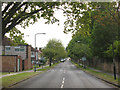
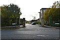
Broad Walk,Kidbrooke
Broad Walk runs almost straight for 1200m south-west from this point.
Image: © Stephen Craven
Taken: 9 May 2009
0.07 miles
3
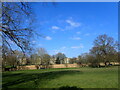
Royal Herbert Pavilions seen from King George's Field
What was first called the Herbert Hospital was opened in 1865. It was built by the authority of Sidney Herbert the 1st Baron Herbert of Lea. Sidney Herbert was responsible for sending Florence Nightingale to the Crimea and led the War Office reforms after this campaign. He was particularly interested in health care and reducing military mortality rates from diseases and ill treated war wounds.
It was the first specially designed military hospital in the country and also the first (of many) to utilize the pavilion design, as advocated by Florence Nightingale, comprising six parallel ward blocks connected by a central corridor. Almost half the 19 acre site was given over to parkland, ensuring a peaceful convalescence for recovering patients.
Queen Victoria visited in March 1900 and was so impressed with the care and treatments of soldiers that she honoured it with royal status and patronage. It then became the Royal Herbert Hospital.
It closed in 1977 when the Queen Elizabeth Military Hospital opened nearby. A Grade II listing, together with incorporation into the Woolwich Common Conservation Area, saved the buildings from demolition. In 1990 the site was bought by a developer and the Royal Herbert Pavilions was completed in 1995. It consists of 228 apartments and contains its own leisure centre.
See https://www.qaranc.co.uk/royalherbert.php and https://ezitis.myzen.co.uk/royalherbert.html for more information and photographs.
The photograph is taken from King George's Field.
Image: © Marathon
Taken: 7 Mar 2021
0.13 miles
4
Edith Cavell Way, London SE18
The view towards Bell Street. The red-brick building nearest the camera - now converted into private apartments - was previously the hospital administration building of the former Brook Hospital, Shooters Hill. Shooters Hill (the A207 road) runs parallel to this street, to the right of the photographer. "The Brook" was closed in 1995 when the Queen Elizabeth (District General) Hospital opened and most of the site was redeveloped into a housing complex, now known as Brook Village. The only remaining former hospital buildings are the water tower, the steward's house (the next one along on the left) the main gate lodge (now a Children's Centre) and this former 'admin' building. Perhaps dating from 1896 - when the hospital was built - the design seems to reflect a Dutch influence.
Image: © David Hallam-Jones
Taken: 3 May 2014
0.13 miles
5
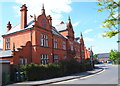
Florence House, Royal Herbert Hospital (former)
Image: © N Chadwick
Taken: 11 Nov 2019
0.13 miles
9
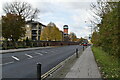
London, SE18 - Shooters Hill Area
A view of the new (c.1995) entrance into the former Royal Herbert (Military) Hospital site from a public footpath on the opposite side of Shooters Hill Road (the A207), near to its junction with Well Hall Road (the A205). The hospital - in its entirety - was commissioned by Sir Sidney Herbert, Minister of War, who commissioned Florence Nightingale and her nurses to go to the Crimean War and who supported her health-related and care-related reforms for British military personnel at home and abroad. This establishment was created as a restorative facility for veterans of the Crimean War and opened in 1865. It eventually became the British Army's principal orthopaedic centre but finally closed in 1977 having became superfluous to military requirements. By 1995, it had been saved from demolition and had been converted into 228 private apartments known collectively as The Royal Herbert Pavilions.
Image: © David Hallam-Jones
Taken: 30 Sep 2012
0.14 miles
10
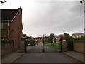
Entrance to Brook Village
Crosier Close leads from Broad Walk (road) into the private housing estate.
This estate was built on the site of the Brook Fever Hospital (demolished in 1990's). It was built by Persminnion Homes as a Millennium project.
Image: © David Anstiss
Taken: 11 Sep 2011
0.14 miles