Edith Cavell Way, London SE18
Introduction
The photograph on this page of Edith Cavell Way, London SE18 by David Hallam-Jones as part of the Geograph project.
The Geograph project started in 2005 with the aim of publishing, organising and preserving representative images for every square kilometre of Great Britain, Ireland and the Isle of Man.

There are currently over 7.5m images from over 14,400 individuals and you can help contribute to the project by visiting https://www.geograph.org.uk
Edith Cavell Way, London SE18
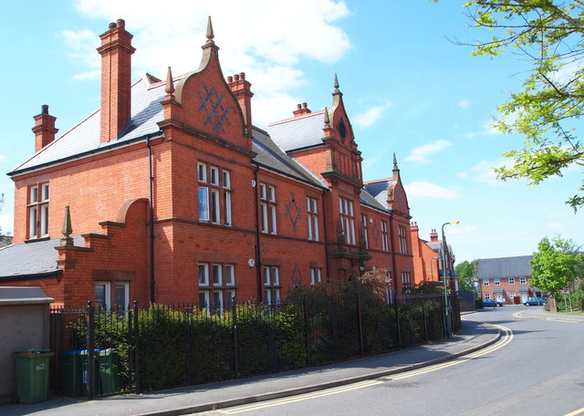
Image: © David Hallam-Jones Taken: 3 May 2014
The view towards Bell Street. The red-brick building nearest the camera - now converted into private apartments - was previously the hospital administration building of the former Brook Hospital, Shooters Hill. Shooters Hill (the A207 road) runs parallel to this street, to the right of the photographer. "The Brook" was closed in 1995 when the Queen Elizabeth (District General) Hospital opened and most of the site was redeveloped into a housing complex, now known as Brook Village. The only remaining former hospital buildings are the water tower, the steward's house (the next one along on the left) the main gate lodge (now a Children's Centre) and this former 'admin' building. Perhaps dating from 1896 - when the hospital was built - the design seems to reflect a Dutch influence.
Images are licensed for reuse under creativecommons.org/licenses/by-sa/2.0
Image Location
Latitude
51.471812
Longitude
0.048302