IMAGES TAKEN NEAR TO
Woolwich Common, LONDON, SE18 4DF
Introduction
This page details the photographs taken nearby to Woolwich Common, SE18 4DF by members of the Geograph project.
The Geograph project started in 2005 with the aim of publishing, organising and preserving representative images for every square kilometre of Great Britain, Ireland and the Isle of Man.

There are currently over 7.5m images from over14,400 individuals and you can help contribute to the project by visiting https://www.geograph.org.uk
Image Map
Images are licensed for reuse under creativecommons.org/licenses/by-sa/2.0
Notes
- Clicking on the map will re-center to the selected point.
- The higher the marker number, the further away the image location is from the centre of the postcode.
Image Listing (59 Images Found)
Images are licensed for reuse under creativecommons.org/licenses/by-sa/2.0
Image
Details
Distance
1
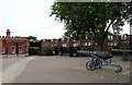
Former Royal Military Academy - SE18
The "Exit Only" gates adjacent to the former East Lodge, with Red Lion Road beyond them.
Image: © David Hallam-Jones
Taken: 6 Aug 2012
0.07 miles
2
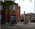
Former Royal Military Academy - SE18
Two cannons appear to be ready to guard the entrance to the sales company's sales office that has been established in the end portion of the former East Officers' Quarters, adjacent to the "Exit Only" gates that open onto Red Lion Lane. The end of the East wing of the main central block that is also awaiting redevelopment can be seen surrounded by black security boarding.
Image: © David Hallam-Jones
Taken: 6 Aug 2012
0.07 miles
3
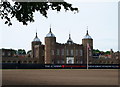
Former Military Academy - SE18
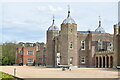
"The Green", this huge bare area in front of the parade ground, has recently been prepared and seeded by Blackheath Cricket Club as a new cricket field. The actual "Parade Ground" is currently inside the construction company's black security fencing. The centre-most building - .i.e. the library building (c.1808) - with its leaded ogee domed octagonal towers was modelled on the White Tower of the Tower of London, where the architect, Sir James Wyatt, worked in his role as Surveyor-General of the Ordnance. A private, gravelled road runs in front of the security fencing from the West Lodge (on the right) to the East Lodge in the other direction, the latter emptying onto Red Lion Road.
Image: © David Hallam-Jones
Taken: 6 Aug 2012
0.08 miles
4
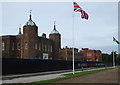
Former Royal Military Academy - SE18
The central building - i.e. the library building (c.1808) - with its leaded ogee domed octagonal towers was modelled on the White Tower of the Tower of London where the architect, Sir James Wyatt, worked in his role as Surveyor-General of the Ordnance. A private, gravelled road can also be seen passing in front of the security fencing from the East Lodge (on the left) to the West Lodge in the other direction, the latter emptying onto Academy Road (a.k.a. the South Circular or A205 road). "The Green", i.e. the bare area on the left has recently been prepared and seeded by Blackheath Cricket Club as a new cricket field, it being a protected "green space" on which building is not permitted.
Image: © David Hallam-Jones
Taken: 6 Aug 2012
0.08 miles
5
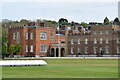
Former Royal Military Academy at Woolwich
Now a substantial residential development.
Image: © David Martin
Taken: 9 May 2021
0.11 miles
6
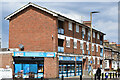
Convenience store on ground floor of flats, Herbert Road
Image: © David Martin
Taken: 9 May 2021
0.12 miles
7
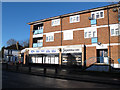
Supermarket on Herbert Road, Plumstead
The shop is on the corner of Whitworth Road.
Image: © Stephen Craven
Taken: 11 Jan 2014
0.12 miles
8
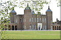
Central building, former Royal Military Academy, Woolwich
Now the centrepiece of a substantial residential development.
Image: © David Martin
Taken: 9 May 2021
0.12 miles
9
View across the front of former Royal Military Academy, Woolwich
Now a substantial residential development.
Image: © David Martin
Taken: 9 May 2021
0.13 miles
10
Former Military Academy - SE18
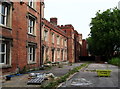
The front elevation of the former "East Officers' Quarters" block that looks out onto Red Lion Lane through the vegetation-lined railings on the right. This block, in common with many others on this former military training base for cadet officers, is waiting to be converted into apartments. Ashmore Road lies behind the photographer. This connects Red Lion Lane with Academy Road (a.k.a. the South Circular Road or the A205), although security gates at either end of it mean that it is not used by the general public.
Image: © David Hallam-Jones
Taken: 6 Aug 2012
0.13 miles