IMAGES TAKEN NEAR TO
Ashmore Road, LONDON, SE18 4AS
Introduction
This page details the photographs taken nearby to Ashmore Road, SE18 4AS by members of the Geograph project.
The Geograph project started in 2005 with the aim of publishing, organising and preserving representative images for every square kilometre of Great Britain, Ireland and the Isle of Man.

There are currently over 7.5m images from over14,400 individuals and you can help contribute to the project by visiting https://www.geograph.org.uk
Image Map
Images are licensed for reuse under creativecommons.org/licenses/by-sa/2.0
Notes
- Clicking on the map will re-center to the selected point.
- The higher the marker number, the further away the image location is from the centre of the postcode.
Image Listing (56 Images Found)
Images are licensed for reuse under creativecommons.org/licenses/by-sa/2.0
Image
Details
Distance
1
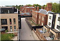
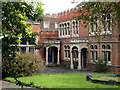
Former Military Academy Site - SE18
An example of an approach to providing affordable housing under Section 106 of the Town and Country Planning Act 1990 can be found on the site of the former Woolwich Military Academy. This view from the 4th floor of a sheltered housing complex (itself part of the Section 106 requirements), reveals a mixture of terraced houses on the right and a block of apartments on the left, behind the garden parasol. Some of these are privately owned, whilst the others fall within the 'social housing' category. Also visible are boarded-up buildings that are waiting to be converted into private housing units. The line of trees are situated on Red Lion Lane.
Image: © David Hallam-Jones
Taken: 6 Aug 2012
0.02 miles
2
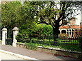
Former Military Academy - SE18
A small garden in front of the former Officers' Mess. This is on one side of Ashmore Road, a road that connects Red Lion Lane (behind the photographer) with Academy Road (a.k.a. the South Circular Road or the A205). Security gates at either end of it however, mean that this former military road it is not usable by the general public.
Image: © David Hallam-Jones
Taken: 6 Aug 2012
0.02 miles
3
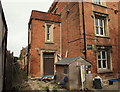
Former Military Academy - SE18
One side of the former "East Officers' Quarters" block. Only the construction site panelling is separating this block from Ashmore Road, a road that connects Red Lion Lane (behind the photographer) with Academy Road (a.k.a. the South Circular Road or the A205). Security gates at either end of it however, mean that this former military road it is not used by the general public. Other blocks are also visible that were once used by its gentlemen soldiers, including the Officers’ Mess, and all of these are apparently waiting to be converted into apartments.
Image: © David Hallam-Jones
Taken: 6 Aug 2012
0.02 miles
4
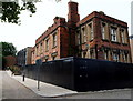
Former Woolwich Military academy, east side
This is the side of the academy building (now a residential conversion) facing Red Lion Lane. The buildings are grade 2* listed (list entry number 1358936).
Image: © Stephen Craven
Taken: 11 Jan 2014
0.02 miles
5
Former Military Academy - SE18
A small garden in front of the former Officers' Mess. This building, along with all of the others on the site, are awaiting redevelopment. The development of the whole site however, is subject to Section 106 of the Town and Country Planning Act 1990 that requires the inclusion of "affordable housing" and social housing. In front of this Mess block is Ashmore Road, a road that connects Red Lion Lane (behind the photographer) with Academy Road (a.k.a. the South Circular Road or the A205). Security gates at either end of it however, mean that this former military road it is not a public route.
Image: © David Hallam-Jones
Taken: 6 Aug 2012
0.02 miles
6
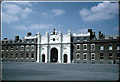
Former Royal Military Academy - SE18
Part of "The Great Hall" (the former Dining Room/s) and the entrance to the former "East Lecture House" from a higher part of the new development, looking across Ashmore Road. Ashmore road is a private, gravelled road between Red Lion Road on one side of the site and Academy Road (a.k.a. the South Circular Road or the A205) on the other, with security gates at each of the two entry/exit points. In the background is the central library building (c.1808) with its leaded ogee domed octagonal towers that was modelled on the White Tower of the Tower of London, where Sir James Wyatt - its architect - was based as Surveyor-General of the Ordnance.
Image: © David Hallam-Jones
Taken: 6 Aug 2012
0.03 miles
7
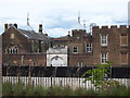
Grand Depot
Royal Artillery Grand Depot block, Woolwich, photographed in 1959. The Royal Artillery, long associated with Woolwich, are now moving to Larkhill in Wiltshire.
Image: © David Wright
Taken: Unknown
0.03 miles
8
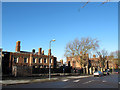
Former Military Academy - SE18
An example of an approach to providing affordable housing under Section 106 of the Town and Country Planning Act 1990 can be found on the site of the former training establishment for gentlemen. In the distance a row of terraced houses can be seen - some of which fall within the category of 'social housing'. In the forefront of this picture is a boarded up former academy block waiting to be converted into private housing units. The road to the photographer's right - once an internal military barracks road - is now referred to as Ashmore Road and it connects Red Lion Lane with Academy Road (a.k.a. the South Circular Road or the A205), although security gates at either end of it mean that it is not a regular thoroughfare.
Image: © David Hallam-Jones
Taken: 6 Aug 2012
0.03 miles
9
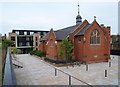
Former Royal Military Academy - SE18
A view of the Church of St Michael and All Angels (1902-04) situated in an area that is now referred to as Village Square by the site developers, together with a block of new houses in the distance. According to their promotional material the developers have already committed themselves to converting the church into an arts and culture centre providing studio space for local artists and an open space for the use of residents for exercise classes, art lessons and cultural events.
Image: © David Hallam-Jones
Taken: 6 Aug 2012
0.03 miles
10
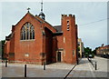
Former Military Academy - SE18
The former Church of St Michael and All Angels (1902-04) is halfway along Ashmore Road, previously a 'military road', and it is currently being used as an on-site architect's office associated with the redevelopment of this former military academy. The whole site is being developed into a mixed complex of private, "affordable homes" and social housing. According to their promotional material the principal developers have already committed themselves to converting this particular building into an arts and culture centre providing studio space for local artists and an open space for the use of residents for exercise classes, art lessons and cultural events. Academy Road (the A205) lies at the end of this private, gravelled road and Red Lion Lane behind the photographer. Beyond the chapel is a recently completed apartment block.
Image: © David Hallam-Jones
Taken: 6 Aug 2012
0.03 miles