IMAGES TAKEN NEAR TO
Campbell Close, LONDON, SE18 3NE
Introduction
This page details the photographs taken nearby to Campbell Close, SE18 3NE by members of the Geograph project.
The Geograph project started in 2005 with the aim of publishing, organising and preserving representative images for every square kilometre of Great Britain, Ireland and the Isle of Man.

There are currently over 7.5m images from over14,400 individuals and you can help contribute to the project by visiting https://www.geograph.org.uk
Image Map
Images are licensed for reuse under creativecommons.org/licenses/by-sa/2.0
Notes
- Clicking on the map will re-center to the selected point.
- The higher the marker number, the further away the image location is from the centre of the postcode.
Image Listing (113 Images Found)
Images are licensed for reuse under creativecommons.org/licenses/by-sa/2.0
Image
Details
Distance
1
Constitution Rise, Woolwich, SE London
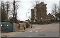
Behind the blue gates a charity have been working part-time for over 6 months to transform an overgrown 5 acre woodland site into an outdoor learning centre for children. The woods, and a pond, were once part of the grounds of a large house that was variously known as The Rookery, The Grove and Goodenough House during the life of the house (c.1800-1936). The house was demolished (c.1936-38) to make way for a council housing estate, a block of which is visible on the corner of Constitution Rise and Moordown.
Image: © David Hallam-Jones
Taken: 20 Mar 2016
0.03 miles
2
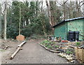
Shooter's Hill Environmental Centre, SE London
Behind a pair of metal gates off Constitution Rise a charity has been working part-time for the last 6-9 months to transform an overgrown 5 acre woodland site and pond into an outdoor learning centre for children. The site was once part of the grounds of a large house that was variously known as The Rookery, The Grove and Goodenough House during its life (c.1800-1936). The house was demolished (c.1936-38) to make way for an adjacent L.C.C. council housing estate on a large corner plot of land formed by the junction of Constitution Rise with Moordown.
Image: © David Hallam-Jones
Taken: 20 Mar 2016
0.03 miles
4
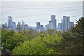
View over trees of distant city skyline
The view from the top of Ankerdine Crescent on Shooters Hill.
Image: © David Martin
Taken: 9 May 2021
0.06 miles
5
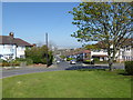
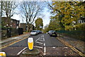
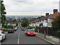
Looking down Donaldson Road, Shooters Hill
The roundabout is at the junction of Donaldson Road and Moordown on the slopes of Shooters Hill. There are superb views to the north down to the Thames.
Image: © Marathon
Taken: 9 Apr 2017
0.07 miles
6
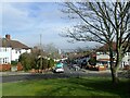
Donaldson Road, Shooters Hill
The views from the northern slopes of Shooters Hill are impressive. This looks down Donaldson Road where Moordown crosses over towards the Thames at Woolwich.
Image: © Marathon
Taken: 20 Feb 2021
0.07 miles
7
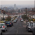
View from Donaldson Road
At an altitude of 115m this road is one of the highest residential streets in London. The view is looking north across the Thames into the north-east part of Greater London, towards Epping Forest.
Image: © Stephen Craven
Taken: 11 Jan 2014
0.08 miles
8
Donaldson Road, Shooters Hill
The views from the northern slopes of Shooters Hill are impressive. This looks down Donaldson Road towards the Thames at Woolwich.
Image: © Marathon
Taken: 20 Feb 2021
0.08 miles
9
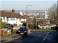
Donaldson Road, Shooters Hill
Donaldson Road is a residential road on Shooters Hill, in south east London. This view looks downhill towards Woolwich.
Image: © Malc McDonald
Taken: 14 Jul 2019
0.08 miles
10
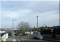
Shooter's Hill, Woolwich, London, SE18
The view from the upper end of Donaldson Road looking across Woolwich. Behind the photographer is a roundabout and a short continuation of this same road linking it with Shooter's Hill (the A207).
Image: © David Hallam-Jones
Taken: 3 Apr 2013
0.08 miles