IMAGES TAKEN NEAR TO
Ankerdine Crescent, LONDON, SE18 3LH
Introduction
This page details the photographs taken nearby to Ankerdine Crescent, SE18 3LH by members of the Geograph project.
The Geograph project started in 2005 with the aim of publishing, organising and preserving representative images for every square kilometre of Great Britain, Ireland and the Isle of Man.

There are currently over 7.5m images from over14,400 individuals and you can help contribute to the project by visiting https://www.geograph.org.uk
Image Map
Images are licensed for reuse under creativecommons.org/licenses/by-sa/2.0
Notes
- Clicking on the map will re-center to the selected point.
- The higher the marker number, the further away the image location is from the centre of the postcode.
Image Listing (57 Images Found)
Images are licensed for reuse under creativecommons.org/licenses/by-sa/2.0
Image
Details
Distance
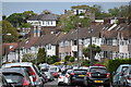
1
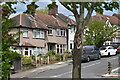
View across roundabout into Donaldson Road
One of several steep streets on the slopes of Shooters Hill.
Image: © David Martin
Taken: 9 May 2021
0.03 miles
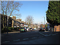
2
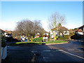
Roundabout on Ankerdine Crescent, Plumstead
The junction with Donaldson Road.
Image: © Stephen Craven
Taken: 11 Jan 2014
0.03 miles
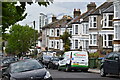
3
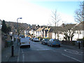
Ankerdine Crescent, Plumstead
Looking south-west from the junction with Paget Rise.
Image: © Stephen Craven
Taken: 11 Jan 2014
0.08 miles
4
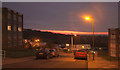
Sunset, Condover Crescent, Shooters Hill
Street lights vie with the sunset in this view from the junction with Eglinton Hill.
Image: © Derek Harper
Taken: 4 Jan 2019
0.11 miles
5
Suburban housing in Moordown, Shooters Hill
Image: © David Martin
Taken: 9 May 2021
0.13 miles
6
Paget Rise, Plumstead
Looking down from the top of the road.
Image: © Stephen Craven
Taken: 11 Jan 2014
0.13 miles
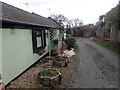
8
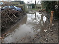
Occupation Lane, Shooters Hill
Occupation Lane is a very old track as can be seen on this pre First World War map where it can be seen running north-south in the centre of the map - https://maps.nls.uk/geo/explore/#zoom=17&lat=51.47384&lon=0.06894&layers=168&b=1
The surface is very poor and is quite narrow in places as seen here.
Image: © Marathon
Taken: 11 Mar 2021
0.15 miles
9
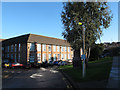
Entrance to Shooters Hill Campus
The "Shooters Hill Post 16 campus" is on Red Lion Lane, Plumstead. It opened in 2002 and incorporates former school buildings.
Image: © Stephen Craven
Taken: 11 Jan 2014
0.15 miles
10
Occupation Lane, Shooters Hill
Occupation Lane is a very old track as can be seen on this pre First World War map where it can be seen running north-south in the centre of the map - https://maps.nls.uk/geo/explore/#zoom=17&lat=51.47384&lon=0.06894&layers=168&b=1
The surface is very poor and is quite narrow in places - see also https://www.geograph.org.uk/photo/6775093
Image: © Marathon
Taken: 11 Mar 2021
0.16 miles