IMAGES TAKEN NEAR TO
Eglinton Hill, LONDON, SE18 3DY
Introduction
This page details the photographs taken nearby to Eglinton Hill, SE18 3DY by members of the Geograph project.
The Geograph project started in 2005 with the aim of publishing, organising and preserving representative images for every square kilometre of Great Britain, Ireland and the Isle of Man.

There are currently over 7.5m images from over14,400 individuals and you can help contribute to the project by visiting https://www.geograph.org.uk
Image Map
Images are licensed for reuse under creativecommons.org/licenses/by-sa/2.0
Notes
- Clicking on the map will re-center to the selected point.
- The higher the marker number, the further away the image location is from the centre of the postcode.
Image Listing (49 Images Found)
Images are licensed for reuse under creativecommons.org/licenses/by-sa/2.0
Image
Details
Distance
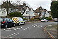
2
Shrewsbury Tumulus
This is a most unlikely setting for a Bronze Age tumulus - amidst suburban roads on the side of Shooters Hill. This view is looking from Plum Lane and the road on the right is Brinklow Crescent. Fortunately there is a notice explaining that this is an ancient tumulus, otherwise the passer by would assume it is just another small piece of remnant grassland lost in suburbia.
Image: © Marathon
Taken: 8 Mar 2011
0.03 miles
3
Shrewsbury Tumulus
This is a most unlikely setting for a Bronze Age tumulus - amidst suburban roads on the side of Shooters Hill. This view looks across Plum Lane and the road on the right is Brinklow Crescent.
Image: © Marathon
Taken: 8 Mar 2011
0.03 miles
4
Shrewsbury Tumulus
This is a most unlikely setting for a Bronze Age tumulus - amidst suburban roads on the side of Shooters Hill. This view is looking from Plum Lane and the road on the right is Brinklow Crescent. Fortunately there is a notice explaining that this is an ancient tumulus, otherwise the passer by would assume it is just another small piece of remnant grassland lost in suburbia.
Image: © Marathon
Taken: 1 Apr 2020
0.04 miles
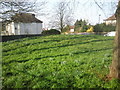
5
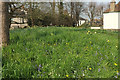
Shrewsbury Barrow
Shrewsbury Barrow is "a substantial earthen mound which survives reasonably well; ... highly representative of the Bronze Age period ... round barrows, particularly surviving in this good a state of preservation, are very rare in London" https://historicengland.org.uk/listing/the-list/list-entry/1430983 . "The last surviving of a group of six. Three of them were known to have formed a linear group, with the remaining two possibly forming or contributing to a second group. The barrows would have been located at the 'false horizon' position where they could be seen silhouetted against the sky from the foot of the hill ... in the mid C19 the barrow stood within the grounds of the mid-C19 Tower House, and it is illustrated with a ring of trees – only some of which remain". See also Image], Image] and Image
Image: © Derek Harper
Taken: 17 Apr 2019
0.05 miles
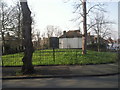
6
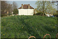
Shrewsbury Barrow
Seen from the stretch of Plum Lane seen in Image Shrewsbury Barrow is "a substantial earthen mound which survives reasonably well; ... highly representative of the Bronze Age period ... round barrows, particularly surviving in this good a state of preservation, are very rare in London" https://historicengland.org.uk/listing/the-list/list-entry/1430983 . "The last surviving of a group of six. Three of them were known to have formed a linear group, with the remaining two possibly forming or contributing to a second group. The barrows would have been located at the 'false horizon' position where they could be seen silhouetted against the sky from the foot of the hill ... in the mid C19 the barrow stood within the grounds of the mid-C19 Tower House, and it is illustrated with a ring of trees – only some of which remain". The house beyond is on Brinklow Crescent.
Image: © Derek Harper
Taken: 17 Apr 2019
0.05 miles
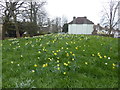
7
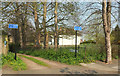
Mayplace Lane, Shrewsbury Park
A back lane between Eglinton Hill and Brinklow Crescent. On the right is an area containing Shrewsbury Barrow, "a substantial earthen mound which survives reasonably well; ... highly representative of the Bronze Age period ... round barrows, particularly surviving in this good a state of preservation, are very rare in London" https://historicengland.org.uk/listing/the-list/list-entry/1430983 . "the last surviving of a group of six. Three of them were known to have formed a linear group, with the remaining two possibly forming or contributing to a second group. The barrows would have been located at the 'false horizon' position where they could be seen silhouetted against the sky from the foot of the hill ... in the mid C19 the barrow stood within the grounds of the mid-C19 Tower House, and it is illustrated with a ring of trees – only some of which remain".
Seen across Plum Lane.
Image: © Derek Harper
Taken: 17 Apr 2019
0.05 miles
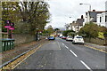
10
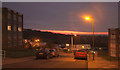
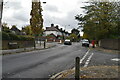
Sunset, Condover Crescent, Shooters Hill
Street lights vie with the sunset in this view from the junction with Eglinton Hill.
Image: © Derek Harper
Taken: 4 Jan 2019
0.06 miles