IMAGES TAKEN NEAR TO
Foxcroft Road, LONDON, SE18 3DB
Introduction
This page details the photographs taken nearby to Foxcroft Road, SE18 3DB by members of the Geograph project.
The Geograph project started in 2005 with the aim of publishing, organising and preserving representative images for every square kilometre of Great Britain, Ireland and the Isle of Man.

There are currently over 7.5m images from over14,400 individuals and you can help contribute to the project by visiting https://www.geograph.org.uk
Image Map
Images are licensed for reuse under creativecommons.org/licenses/by-sa/2.0
Notes
- Clicking on the map will re-center to the selected point.
- The higher the marker number, the further away the image location is from the centre of the postcode.
Image Listing (104 Images Found)
Images are licensed for reuse under creativecommons.org/licenses/by-sa/2.0
Image
Details
Distance
1
Foxcroft Road, Shooters Hill
In the very centre of this photograph from high on Shooters Hill is a distant view of Canary Wharf in London Docklands.
Image: © David Martin
Taken: 16 Jan 2012
0.01 miles
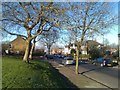
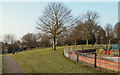
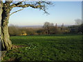
2
Eaglesfield Recreation Ground
This view looks across Eaglesfield Recreation Ground to the houses in Foxcroft Road. Eaglesfield Recreation Ground is situated on the upper slopes of Shooters Hill and provides fine views to the east.
Image: © Marathon
Taken: 7 Mar 2011
0.04 miles
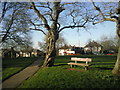
4
Eaglesfield Park
The land now forming Eaglesfield Park has a long history. Excavations carried out in 2007 found the remains of an early Iron Age foundry, indicating that there was early human settlement here. The southern edge of the park was part of an extensive pleasure garden in the 18th century. The name for Eaglesfield is thought to have derived from the coat of arms of John Lidgbird who was High Sheriff of Kent in 1741 and owned the site. His coat of arms displayed two eagles.
Land for the modern-day park was purchased by Woolwich Metropolitan Council in 1907 and the park was opened in 1908. An anti-Zeppelin gun was located here during the First World War and a barrage balloon in the Second World War which was used to defend against low-level aircraft attacks.
Eaglesfield Park is at the top of Shooters Hill, which is the second highest point in London. There are extensive views across Kent and Essex and towards the Thames Estuary. The Green Chain Walk passes through the park.
There is a Friends of Eaglesfield Park - see https://eaglesfieldpark.org/
For a more detailed description see http://londongardensonline.org.uk/gardens-online-record.php?ID=GRN016
Image: © Marathon
Taken: 3 Apr 2020
0.07 miles
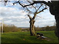
5
Shooter's Hill, Woolwich, London, SE18
Walkers crossing Eaglesfield Recreation Ground from Foxcroft Road to Eaglesfield Road inevitable pass this children's play area. Twenty or so years ago it used to be a large paddling pool but now it simply accommodates playground equipment. The 1910 water tower that can be seen through the trees pinpoints the junction of Shooter's Hill (the A207) and Cleanthus Road.
Image: © David Hallam-Jones
Taken: 3 Apr 2013
0.07 miles
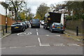
6
Cleanthus Road, Shooters Hill
The road heads towards Shooters Hill but there is a curious hiatus; its last 40 metres are offset and cannot be accessed from the rest of the road. You can get through on foot, though.
Image: © Derek Harper
Taken: 24 Feb 2019
0.07 miles
7
Eaglesfield Park
The land now forming Eaglesfield Park has a long history. Excavations carried out in 2007 found the remains of an early Iron Age foundry, indicating that there was early human settlement here. The southern edge of the park was part of an extensive pleasure garden in the 18th century. The name for Eaglesfield is thought to have derived from the coat of arms of John Lidgbird who was High Sheriff of Kent in 1741 and owned the site. His coat of arms displayed two eagles.
Land for the modern-day park was purchased by Woolwich Metropolitan Council in 1907 and the park was opened in 1908. An anti-Zeppelin gun was located here during the First World War and a barrage balloon in the Second World War which was used to defend against low-level aircraft attacks.
Eaglesfield Park is at the top of Shooters Hill, which is the second highest point in London. There are extensive views across Kent and Essex and towards the Thames Estuary. The Green Chain Walk passes through the park.
There is a Friends of Eaglesfield Park - see https://eaglesfieldpark.org/
For a more detailed description see http://londongardensonline.org.uk/gardens-online-record.php?ID=GRN016
Image: © Marathon
Taken: 3 Apr 2020
0.08 miles
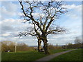
8
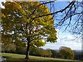
Eaglesfield Recreation Ground in autumn
Eaglesfield Recreation Ground on the higher eastern slopes of Shooters Hill provides fine views across the Thames and into Essex and Kent.
Image: © Marathon
Taken: 10 Nov 2017
0.08 miles
9
View from Shooters Hill
Eaglesfield Recreation Ground on the higher eastern slopes of Shooters Hill provides fine views across the Thames and into Essex and Kent.
Image: © Marathon
Taken: 7 Mar 2011
0.08 miles
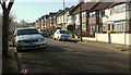
10
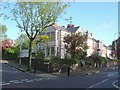
Houses on Eaglesfield Road, SE18
A terrace of four, at the junction with Foxcroft Road (left).
Image: © Derek Harper
Taken: 20 May 2006
0.08 miles