IMAGES TAKEN NEAR TO
Alliance Road, LONDON, SE18 2BE
Introduction
This page details the photographs taken nearby to Alliance Road, SE18 2BE by members of the Geograph project.
The Geograph project started in 2005 with the aim of publishing, organising and preserving representative images for every square kilometre of Great Britain, Ireland and the Isle of Man.

There are currently over 7.5m images from over14,400 individuals and you can help contribute to the project by visiting https://www.geograph.org.uk
Image Map
Images are licensed for reuse under creativecommons.org/licenses/by-sa/2.0
Notes
- Clicking on the map will re-center to the selected point.
- The higher the marker number, the further away the image location is from the centre of the postcode.
Image Listing (226 Images Found)
Images are licensed for reuse under creativecommons.org/licenses/by-sa/2.0
Image
Details
Distance
1
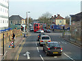
Junction on Wickham Lane, A209
96 and 422 buses squeeze past each other.
Image: © Robin Webster
Taken: 14 Mar 2012
0.07 miles
3
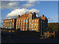
Former St Paul's school, Plumstead
Originally a Catholic secondary school, more recently an Academy. The Academy has now moved to a new site about 1.5km away Image and I am unsure what this old building is used for now. The high-stacked temporary buildings used for a while when the academy first expanded on this site Image have now gone.
Image: © Stephen Craven
Taken: 1 Nov 2014
0.10 miles
4
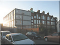
St Paul's school, Abbey Wood
A Roman Catholic secondary school.
Image: © Stephen Craven
Taken: 7 Dec 2008
0.10 miles
5
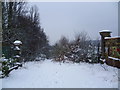
Southland Road, Plumstead in the snow
Southland Road lies in between Rockliffe Gardens and Woolwich New Cemetery. It leads from Camdale Road making a right-angled bend by the entrance to Rockliffe Gardens, and then another right-angled bend whereupon it reduces to a track and heads downhill towards King's Highway. This is the point at which it becomes a track. Rockliffe Gardens is on the left and the end of Woolwich New Cemetery is on the right.
Image: © Marathon
Taken: 5 Feb 2012
0.12 miles
6
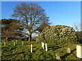
War graves in Woolwich New Cemetery
Woolwich Cemetery is in two parts, the Old Cemetery to the west and the New Cemetery to the east. The Old Cemetery was laid out by Woolwich Burial Board in 1856 and the land for the New Cemetery was purchased in 1885 and is still in use. It contains graves of those who died in explosions at the Royal Arsenal, as well as the War Memorial and a number of War Graves, including one recipient of the Victoria Cross.
Image: © Marathon
Taken: 28 Feb 2021
0.13 miles
7
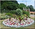
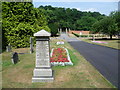
Flower bed near main entrance, Woolwich Old Cemetery
Woolwich Cemetery is in two parts, west and east, divided by Rockliffe Gardens. This is the Old Cemetery to the west, founded in 1856 by the Woolwich Burial Board. They laid out the 12-acre site which was formerly part of Plumstead Common. This is at the lowest part of the cemetery with the gate leading out to King's Highway beyond. The trees on the far side of King's Highway are on the slope of Winn's Common, which is the eastern part of Plumstead Common.
Image: © Marathon
Taken: 27 Jul 2013
0.13 miles
8
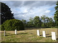
First World War graves in Woolwich New Cemetery
Woolwich Cemetery is in two parts, the Old Cemetery to the west and the New Cemetery to the east. The Old Cemetery was laid out by Woolwich Burial Board in 1856 and the land for the New Cemetery was purchased in 1885 and is still in use. It contains graves of those who died in explosions at the Royal Arsenal, as well as the War Memorial and a number of War Graves, including one recipient of the Victoria Cross - see https://www.geograph.org.uk/photo/6462787
This is part of a scattered grouping of war graves in the north-east part of the cemetery but there are a great many others scattered all around the cemetery. One group together can be seen at https://www.geograph.org.uk/photo/6465528
Image: © Marathon
Taken: 28 Jun 2020
0.13 miles
9
The Sales monument in Woolwich Old Cemetery
Woolwich Cemetery is in two parts, west and east, divided by Rockliffe Gardens. This is the Old Cemetery to the west, founded in 1856 by the Woolwich Burial Board. They laid out the 12-acre site which was formerly part of Plumstead Common. This is near the bottom part of the cemetery with the gate leading out to King's Highway beyond. The trees on the far side of King's Highway are on the slope of Winn's Common, which is the eastern part of Plumstead Common.
The monument in the foreground is to JOHN MATTHEW SALES, ENGINEER R.N. LATE IN CHARGE OF FLOATING FACTORY DEVONPORT WHO DIED 13TH MAY 1865 AGED 35 YEARS. The inscription also includes his daughter Sarah Ann who died almost exactly a year later aged 15 and was buried in Old Alresford Churchyard in Hampshire and his son John Samuel who died in 1883 aged 24 and was buried at Penzance.
Image: © Marathon
Taken: 27 Jul 2013
0.13 miles
10
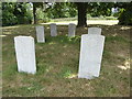
First World War graves in Woolwich New Cemetery
Woolwich Cemetery is in two parts, the Old Cemetery to the west and the New Cemetery to the east. The Old Cemetery was laid out by Woolwich Burial Board in 1856 and the land for the New Cemetery was purchased in 1885 and is still in use. It contains graves of those who died in explosions at the Royal Arsenal, as well as the War Memorial and a number of War Graves, including one recipient of the Victoria Cross - see https://www.geograph.org.uk/photo/6462787
This is part of a scattered grouping of war graves in the north-east part of the cemetery but there are a great many others scattered all around the cemetery. One group together can be seen at https://www.geograph.org.uk/photo/6465528
Image: © Marathon
Taken: 28 Jun 2020
0.13 miles