IMAGES TAKEN NEAR TO
Flora Mews, LONDON, SE18 2AL
Introduction
This page details the photographs taken nearby to Flora Mews, SE18 2AL by members of the Geograph project.
The Geograph project started in 2005 with the aim of publishing, organising and preserving representative images for every square kilometre of Great Britain, Ireland and the Isle of Man.

There are currently over 7.5m images from over14,400 individuals and you can help contribute to the project by visiting https://www.geograph.org.uk
Image Map
Images are licensed for reuse under creativecommons.org/licenses/by-sa/2.0
Notes
- Clicking on the map will re-center to the selected point.
- The higher the marker number, the further away the image location is from the centre of the postcode.
Image Listing (124 Images Found)
Images are licensed for reuse under creativecommons.org/licenses/by-sa/2.0
Image
Details
Distance
2
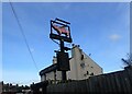
A flying pig
The pub is called 'The Who'd 'a' Thought It' so a flying pig on the sign seems right. This is on Timbercroft Lane near Plumstead Common.
Image: © Marathon
Taken: 15 Feb 2021
0.02 miles
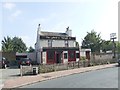
3
The Who'd 'a' Thought It Public house, Plumstead
On Timbercroft Lane.
Image: © David Anstiss
Taken: 21 Aug 2011
0.03 miles
5
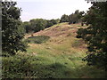
Wilder part of Plumstead Common
As seen from Plumstead Common Road.
Most of Plumstead Common is flat recreational ground. But near the Slade is a wilder valley part.
Image: © David Anstiss
Taken: 21 Aug 2011
0.07 miles
6
Catholic Church of the Holy Cross, Plumstead
On the Slade, opposite Plumstead Common.
Image: © David Anstiss
Taken: 21 Aug 2011
0.08 miles
7
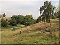
Valley in Plumstead Common
As seen from a path near Plumstead Common Road.
Most of Plumstead Common is flat recreational ground. But near the Slade is a wilder valley part. Leading towards Roydene Road.
Image: © David Anstiss
Taken: 21 Aug 2011
0.09 miles
8
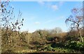
The Slade at Plumstead Common
Plumstead Common is as near as the North of England you can get in London. It has ravines, steep steps and houses built up hillsides. This view is of the ravine known as The Slade. The white building just seen at the top is the hall of St Mark's with St Margaret's Church.
Image: © Marathon
Taken: 17 Jan 2021
0.09 miles
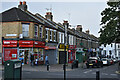
9
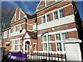
Plumstead Common Working Men's Club & Institute
Plumstead Common Working Men's Club & Institute is where local lad Steve Davis learned to play snooker. His Wikipedia entry says:
"Steve Davis, OBE (born 22 August 1957) is a retired English professional snooker player from Plumstead, London. He dominated the sport during the 1980s, when he reached eight World Snooker Championship finals in nine years, won six world titles, held the world number one ranking for seven consecutive seasons, and became the first snooker player to earn over £1 million in prize money. His encounter with Dennis Taylor in the 1985 World Championship final is widely noted as one of the most famous matches in snooker history. Decided on the final black, it set a record post-midnight UK television audience of 18.5 million viewers. The BBC named Davis its Sports Personality of the Year in 1988, and he remains the only snooker player ever to win the award."
A close up of the doorway and the inscription over it can be seen at https://www.geograph.org.uk/photo/6732022
Image: © Marathon
Taken: 17 Jan 2021
0.09 miles
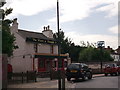
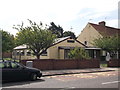
10
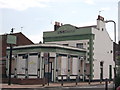
The Woodman, Public House, Plumstead
Closed public house on the junction of The Slade (road in front) and Ravine Grove (on the right).
Image: © David Anstiss
Taken: 21 Aug 2011
0.09 miles