IMAGES TAKEN NEAR TO
Heavitree Road, LONDON, SE18 1SU
Introduction
This page details the photographs taken nearby to Heavitree Road, SE18 1SU by members of the Geograph project.
The Geograph project started in 2005 with the aim of publishing, organising and preserving representative images for every square kilometre of Great Britain, Ireland and the Isle of Man.

There are currently over 7.5m images from over14,400 individuals and you can help contribute to the project by visiting https://www.geograph.org.uk
Image Map (Loading...)


Getting Data...Please wait
Leaflet Map data © OpenStreetMap
Images are licensed for reuse under creativecommons.org/licenses/by-sa/2.0
Notes
- Clicking on the map will re-center to the selected point.
- The higher the marker number, the further away the image location is from the centre of the postcode.
Image Listing (111 Images Found)
Images are licensed for reuse under creativecommons.org/licenses/by-sa/2.0
Image
Details
Distance
1
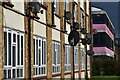
Apartments and school building, Ancona Road
Image: © David Martin
Taken: 3 Oct 2021
0.08 miles
2
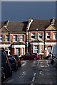
Houses in Ancona Road, just after a storm
Image: © David Martin
Taken: 3 Oct 2021
0.08 miles
3
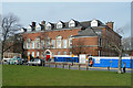
Plumstead Manor School
Overlooking Plumstead Common.
Image: © Robin Webster
Taken: 14 Mar 2012
0.08 miles
4
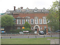
Plumstead Manor School
A girls' comprehensive school on Old Mill Road. For a history of the building and the school establishment, see http://www.plumsteadmanor.com/
Image: © Stephen Craven
Taken: 9 May 2010
0.09 miles
5
Plumstead Common in autumn
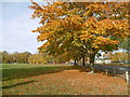
Plumstead Common was purchased for the people in 1877. Before that, the parish council had grazing rights and free access, even though the land was owned by Queens College, Oxford. From 1871 the college had allowed the Army access and it was largely turned into a military training ground. This led to a storm of protest and a procession to the Common took place. Their leader was temporarily imprisoned and further protest took place until an Act of Parliament authorised purchase of the Common by the Metropolitan Board of Works.
This autumnal view looks across Warwick Terrace towards Plumstead Manor School.
Image: © Marathon
Taken: 31 Oct 2016
0.09 miles
6
Plumstead Common in autumn
Plumstead Common was purchased for the people in 1877. Before that, the parish council had grazing rights and free access, even though the land was owned by Queens College, Oxford. From 1871 the college had allowed the Army access and it was largely turned into a military training ground. This led to a storm of protest and a procession to the Common took place. Their leader was temporarily imprisoned and further protest took place until an Act of Parliament authorised purchase of the Common by the Metropolitan Board of Works.
This autumnal view looks across Warwick Terrace towards Plumstead Manor School.
Image: © Marathon
Taken: 31 Oct 2016
0.09 miles
7
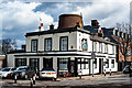
Plumstead : "The Old Mill" public house
"The pub developed from an 18th century windmill, the core of which still remains and towers over the pub building" - https://whatpub.com/pubs/SEL/10745/old-mill-plumstead.
Image: © Jim Osley
Taken: 24 Feb 2022
0.10 miles
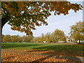
8
View across The Slade at Plumstead Common
The Slade is a ravine on Plumstead Common with a pond at the bottom. This view looks across to to the houses on Old Mill Road and Plumstead Manor School which is in the centre. See also https://www.geograph.org.uk/photo/6448476
Image: © Marathon
Taken: 20 Feb 2021
0.10 miles
9
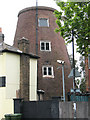
Plumstead windmill
The brick tower is the remains of an 18th century windmill. The site was an obvious one, on the top of the escarpment on the edge of Plumstead Common where it would make the most of the prevailing wind. The tower is grade 2 listed (listed building no. 200464) and appears to have been converted to residential use.
Image: © Stephen Craven
Taken: 9 May 2010
0.10 miles
10
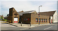
St Mark & St Margaret, Old Mill Road, Plumstead
Image: © John Salmon
Taken: 9 Jul 2010
0.10 miles