IMAGES TAKEN NEAR TO
Fox Hollow Close, LONDON, SE18 1RX
Introduction
This page details the photographs taken nearby to Fox Hollow Close, SE18 1RX by members of the Geograph project.
The Geograph project started in 2005 with the aim of publishing, organising and preserving representative images for every square kilometre of Great Britain, Ireland and the Isle of Man.

There are currently over 7.5m images from over14,400 individuals and you can help contribute to the project by visiting https://www.geograph.org.uk
Image Map (Loading...)


Getting Data...Please wait
Leaflet Map data © OpenStreetMap
Images are licensed for reuse under creativecommons.org/licenses/by-sa/2.0
Notes
- Clicking on the map will re-center to the selected point.
- The higher the marker number, the further away the image location is from the centre of the postcode.
Image Listing (120 Images Found)
Images are licensed for reuse under creativecommons.org/licenses/by-sa/2.0
Image
Details
Distance
1
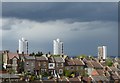
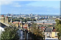
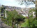
Storm clouds over Plumstead
This was a day of heavy showers and some bright sunshine. Despite appearances, there was no rain locally for much of the rest of the day although I would imagine it was fairly wet over north-east London which was the direction this photograph was taken. This was from Sladedale Road in Plumstead looking across the roofs in Roydene Road to the houses in Parkdale Road. The tower blocks are on the Glyndon Estate.
Image: © Marathon
Taken: 1 May 2020
0.03 miles
2
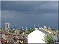
Storm clouds over Plumstead
This was a day of heavy showers and some bright sunshine. Despite appearances, there was no rain locally for much of the rest of the day although I would imagine it was fairly wet over north-east London which was the direction this photograph was taken. This was from Sladedale Road in Plumstead looking across the roofs in Roydene Road to the houses in Parkdale Road. The distant grey tower blocks in the centre of the photograph are at the new development at the Royal Arsenal.
Image: © Marathon
Taken: 1 May 2020
0.04 miles
3
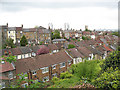
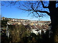
Roofs of Roydene Road
This is an unusual sort of view for London, a generally flattish city. But Plumstead has some of the steepest hills in the city; this is looking down from Sladedale Road onto the rooftops of the adjacent street, Roydene Road. The tower blocks in the distance are in Woolwich.
Image: © Stephen Craven
Taken: 9 May 2010
0.06 miles
4
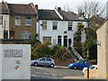
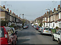
Houses on Parkdale Road, Plumstead
Looking from the end of Roydene Road via a short length of Sladedale Road. All in postal area SE18.
Image: © Robin Webster
Taken: 14 Mar 2012
0.07 miles
5
Roydene Road meets Sladedale Road, Plumstead
Image: © Robin Webster
Taken: 14 Mar 2012
0.09 miles
6
View over rooftops on Sladedale Road
Distant view to Beckton, north of the River Thames.
Image: © David Martin
Taken: 3 Oct 2021
0.09 miles
7
A hillside of houses in Plumstead
Plumstead Common is as near to the North of England or South Wales as you can get in London. It has ravines, steep steps and houses built up hillsides. This view is from steps leading from Lakedale Road down the side of the ravine known as The Slade and its pond, as seen at https://www.geograph.org.uk/photo/6732531
The backs of the houses in Chestnut Rise are at the top here, while below those are the houses in Tormount Road and at the very bottom are houses in Roydene Road.
Image: © Marathon
Taken: 9 Mar 2021
0.10 miles
9
View from the steps leading up to Lakedale Road
Plumstead Common is as near as the North of England you can get in London. It has ravines, steep steps and houses built up hillsides. This view is from the steps leading up from the Slade Ponds to Lakedale Road and Winns Common which is part of Plumstead Common and looks past the cottages seen at https://www.geograph.org.uk/photo/6447559 towards Tormount Road.
The steps are also seen at https://www.geograph.org.uk/photo/6447557 with the cottages to the left.
Image: © Marathon
Taken: 15 Apr 2020
0.10 miles
10
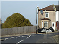
Tormount Road - Steep Hill 20%
Tormount Road, Plumstead. 20% steep hill up sign.
Image: © Adam Morse
Taken: 8 Aug 2009
0.11 miles