IMAGES TAKEN NEAR TO
Grosmont Road, LONDON, SE18 1LH
Introduction
This page details the photographs taken nearby to Grosmont Road, SE18 1LH by members of the Geograph project.
The Geograph project started in 2005 with the aim of publishing, organising and preserving representative images for every square kilometre of Great Britain, Ireland and the Isle of Man.

There are currently over 7.5m images from over14,400 individuals and you can help contribute to the project by visiting https://www.geograph.org.uk
Image Map
Images are licensed for reuse under creativecommons.org/licenses/by-sa/2.0
Notes
- Clicking on the map will re-center to the selected point.
- The higher the marker number, the further away the image location is from the centre of the postcode.
Image Listing (66 Images Found)
Images are licensed for reuse under creativecommons.org/licenses/by-sa/2.0
Image
Details
Distance
1
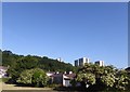
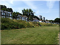
View from the Green Chain Walk near Wickham Lane
The Green Chain Walk here drops down from Bostall Woods to cross this patch of grassland in between houses before crossing Wickham Lane, houses of which can be seen on the far left. The Green Chain Walk then rises up steeply through the woods ahead to reach Plumstead Common. The flats on the right are around Grosmont Road.
Image: © Marathon
Taken: 25 May 2020
0.02 miles
2
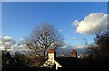
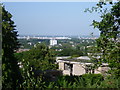
View at Plumstead Common
This view is at the top of Grosmont Road where it reaches Winn Common Road. The views across London are extensive.
Image: © Marathon
Taken: 5 Feb 2021
0.11 miles
3
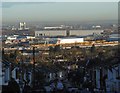
Early morning view down Purrett Road
Purrett Road drops steeply down from Plumstead Common to Lower Plumstead. In this view, taken not long after sunrise, the Barking Creek Barrier is to the left, the two big grey buildings in the distance are known as 'Iron Mountain' - see http://www.geograph.org.uk/photo/2990467 while in front of these the lines of yellow wagons are within a worksite for Crossrail, situated between Woolwich and the southern terminus at Abbey Wood.
Image: © Marathon
Taken: 19 Feb 2016
0.12 miles
4
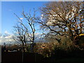
Chimney pots at Plumstead Common
This view is at the top of Grosmont Road where it reaches Winn Common Road. The views across London are extensive. The chimneys belong to a house at the top of Purrett Road.
Image: © Marathon
Taken: 5 Feb 2021
0.12 miles
5

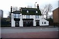
Plume of Feathers Pub Sign, Plumstead
As seen on Image
Image: © David Anstiss
Taken: 21 Aug 2011
0.13 miles
6
Open land alongside Wickham Lane
Part of the Green Chain Walk runs parallel to the road here.
Image: © Stephen Craven
Taken: 14 Jul 2013
0.14 miles
9
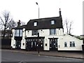
Plume Of Feathers Public House
Opposite St Nicholas Gardens at the top of St Nicholas Road is the Plume of Feathers Public House. To the east of the pub is a large garden that was used by visitors using the terminus that used to be beside the pub in front of the gardens. The west side entrance leads to the old stables as the Inn was a coach stop before trams.
Image: © Ken Brown
Taken: 3 Feb 2003
0.16 miles
10
View from Winn's Common
Winn's Common is the eastern part of Plumstead Common. Although this was once heathland there is now no heather to be found although plants such as gorse are still to be seen. However, names such as Heath Villas and Heathfield Terrace are reminders of what was once here. There are also tremendous views across the Thames basin as seen here from a spur between Riverdale Road and Purrett Road. The wind pump is across the river in Dagenham.
Image: © Marathon
Taken: 5 Sep 2012
0.16 miles