IMAGES TAKEN NEAR TO
Brookdene Road, LONDON, SE18 1EJ
Introduction
This page details the photographs taken nearby to Brookdene Road, SE18 1EJ by members of the Geograph project.
The Geograph project started in 2005 with the aim of publishing, organising and preserving representative images for every square kilometre of Great Britain, Ireland and the Isle of Man.

There are currently over 7.5m images from over14,400 individuals and you can help contribute to the project by visiting https://www.geograph.org.uk
Image Map
Images are licensed for reuse under creativecommons.org/licenses/by-sa/2.0
Notes
- Clicking on the map will re-center to the selected point.
- The higher the marker number, the further away the image location is from the centre of the postcode.
Image Listing (72 Images Found)
Images are licensed for reuse under creativecommons.org/licenses/by-sa/2.0
Image
Details
Distance
1
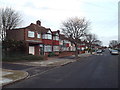
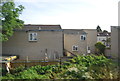
Brookdene Road, Plumstead
Brookdene Road is a residential road in Plumstead, in the suburbs of south east London.
Image: © Malc McDonald
Taken: 30 Dec 2017
0.01 miles
2
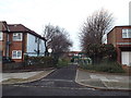
Entrance to Plumstead Gardens, Plumstead
Plumstead gardens is a small recreation ground in Plumstead, in the south east London suburbs. This image shows the entrance gate, on Brookdene Road.
Image: © Malc McDonald
Taken: 30 Dec 2017
0.03 miles
3
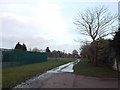
Plumstead Gardens, Plumstead
Plumstead Gardens is a small recreation ground in Plumstead, in the suburbs of south east London.
This photograph was taken on a late December afternoon, not long before dusk.
Image: © Malc McDonald
Taken: 30 Dec 2017
0.04 miles
4
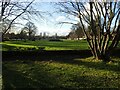
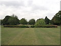
Plumstead Gardens
Plumstead Gardens was created after the Second World War, at around the same period as other public gardens in the area, such as Well Hall Pleasaunce and Bostall Gardens. They all share similar architectural features. Prior to this the land was used for allotment gardens.
The park gates retain the crest of the Metropolitan Borough of Woolwich, and it was originally laid out as an ornamental garden with a notable area of hard landscaping comprising a raised terrace at the east end, with an ornate sunken formal garden with central pool, walks and rose beds.
The park used to have a permanent park keeper, but after this ceased to be the case in the early 1990s the park suffered neglect and vandalism. The formal ponds were drained and some of the stonework damaged, and this area was later demolished and infilled.
Image: © Marathon
Taken: 5 Feb 2021
0.09 miles
6
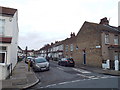
Balgowan Street, Plumstead
Balgowan Street is a residential road in Plumstead, in the suburbs of south east London.
Image: © Malc McDonald
Taken: 30 Dec 2017
0.10 miles
7
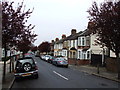
Plumstead Garden
A rectangle of land near Church Manor Way has been used by the council as recreational ground, with a small hedged formal garden within the centre.
Though unfortunely not maintained apart from the hedges being cut.
Image: © David Anstiss
Taken: 21 Aug 2011
0.12 miles
9
St Nicholas, Plumstead, London SE18 - Font
Image: © John Salmon
Taken: 22 Sep 2010
0.13 miles
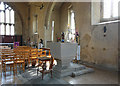
10
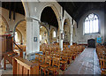
St Nicholas, Plumstead, London SE18 - Interior
Image: © John Salmon
Taken: 22 Sep 2010
0.13 miles