IMAGES TAKEN NEAR TO
Abery Street, LONDON, SE18 1DD
Introduction
This page details the photographs taken nearby to Abery Street, SE18 1DD by members of the Geograph project.
The Geograph project started in 2005 with the aim of publishing, organising and preserving representative images for every square kilometre of Great Britain, Ireland and the Isle of Man.

There are currently over 7.5m images from over14,400 individuals and you can help contribute to the project by visiting https://www.geograph.org.uk
Image Map (Loading...)


Getting Data...Please wait
Leaflet Map data © OpenStreetMap
Images are licensed for reuse under creativecommons.org/licenses/by-sa/2.0
Notes
- Clicking on the map will re-center to the selected point.
- The higher the marker number, the further away the image location is from the centre of the postcode.
Image Listing (82 Images Found)
Images are licensed for reuse under creativecommons.org/licenses/by-sa/2.0
Image
Details
Distance
1
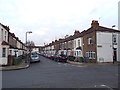
Gunning Street, Plumstead
Gunning Street is a residential road in Plumstead, in the suburbs of south east London.
Image: © Malc McDonald
Taken: 30 Dec 2017
0.02 miles
2
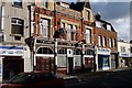
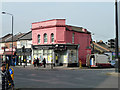
O'Dowds Public House
Situated at 67 Plumstead High Street, Plumstead, London, SE18 1SB in between the motor factors and the glass shop on the north side of the road. It used to be The Green Man and then The Two Moons before changing to O'Dowds.
Image: © Ken Brown
Taken: 3 Feb 2003
0.04 miles
6
Plumstead Community Law Centre
On Plumstead High Street at the corner of White Hart Road.
Image: © Robin Webster
Taken: 14 Mar 2012
0.07 miles
7
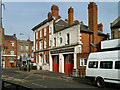
LCC Fire Brigade Station, Plvmstead
So says the inscription over the doors. It appears to be still operational, but presumably the fire brigade has a different title now. And hopefully they have dropped the affectation of using 'v' for 'u'.
Image: © Robin Webster
Taken: 14 Mar 2012
0.10 miles
8
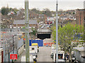
White Hart Road, closed for Crossrail
For a view of the railway bridge in the centre of the photo when it was open to traffic, see Image
Image: © Stephen Craven
Taken: 19 Apr 2015
0.10 miles
9
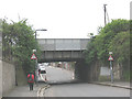
Railway bridge over White Hart Road
This photo is taken from the north side of the bridge, on the part of White Hart Road (an industrial area) which is effectively cut off by the bridge to any vehicle over 10ft 9in high (quite low compared with most railway bridges). The railway is the North Kent Line from London to Dartford via Greenwich.
Image: © Stephen Craven
Taken: 9 May 2010
0.11 miles
10

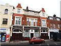
The Volunteer Public House, Plumstead
Image: © Nigel Thompson
Taken: 15 Apr 2025
0.11 miles