IMAGES TAKEN NEAR TO
Hawksmoor Close, LONDON, SE18 1BJ
Introduction
This page details the photographs taken nearby to Hawksmoor Close, SE18 1BJ by members of the Geograph project.
The Geograph project started in 2005 with the aim of publishing, organising and preserving representative images for every square kilometre of Great Britain, Ireland and the Isle of Man.

There are currently over 7.5m images from over14,400 individuals and you can help contribute to the project by visiting https://www.geograph.org.uk
Image Map
Images are licensed for reuse under creativecommons.org/licenses/by-sa/2.0
Notes
- Clicking on the map will re-center to the selected point.
- The higher the marker number, the further away the image location is from the centre of the postcode.
Image Listing (67 Images Found)
Images are licensed for reuse under creativecommons.org/licenses/by-sa/2.0
Image
Details
Distance
1
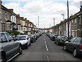
Plumstead: Riverdale Road, SE18
This is Riverdale Road viewed looking down towards the High Street. The pale blue column is a sewer vent pipe, the top of which must be higher than the ridges of the house roofs.
Image: © Nigel Cox
Taken: 15 Apr 2008
0.07 miles
2
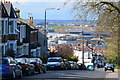
View down Lakedale Road
Her Majesty's Prison, Belmarsh is in the middle distance. The far distance is to the north of the Thames.
Image: © David Martin
Taken: 12 Apr 2016
0.08 miles
3
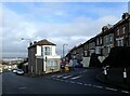
Lakedale Road, Plumstead
The roads leading down from Plumstead Common towards the Thames are very steep which makes many of the houses well above street level. This must make it very difficult to move furniture in and out. This is at the junction with Tewson Road which is on the right.
Image: © Marathon
Taken: 4 Feb 2021
0.09 miles
4
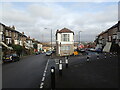
Lakedale Road, Plumstead
The roads leading down from Plumstead Common towards the Thames are very steep which makes many of the houses well above street level. This must make it very difficult to move furniture in and out. This is at the junction with Tewson Road which is on the right.
Image: © Marathon
Taken: 4 Feb 2021
0.09 miles
5
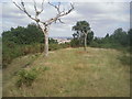
Acid grassland on Winns Common
The underlying soils on Winns Common are poor and gravelly and so the grasses tend to stay short. Gorse is also typical of these soils. The extensive views northwards extend well beyond the Thames to the Essex hills - places such as Havering-atte-Bower.
Image: © Marathon
Taken: 30 Aug 2010
0.09 miles
6
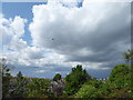
A stormy sky seen from Plumstead Common
This was a day of heavy showers and some bright sunshine. Despite appearances, there was no rain locally for much of the rest of the day although I would imagine it was fairly wet over north-east London and Canary Wharf which can be seen in the direction this photograph was taken. This view looks across Lakedale Road.
Image: © Marathon
Taken: 1 May 2020
0.11 miles
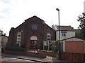
8
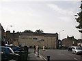
Christ the King Church, Plumstead
On the junction of Brewery Road (on the right) and Lakedale Road (on the left).
Image: © David Anstiss
Taken: 21 Aug 2011
0.11 miles
9
Christ the King Church (2), Plumstead
On the junction of Brewery Road (in front) and Lakedale Road (behind the church).
Image: © David Anstiss
Taken: 21 Aug 2011
0.12 miles
10
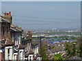
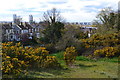
Viewland Road, Plumstead Common
Plumstead Common is as near as the North of England you can get in London. It has ravines, steep steps and houses built up hillsides. It also has excellent views across to the River Thames and to north-east London.
This view looks down Viewland Road. The Barking Creek Barrier is clearly visible right of centre, and Belmarsh Prison is in front of it.
Image: © Marathon
Taken: 15 Apr 2020
0.12 miles