IMAGES TAKEN NEAR TO
Ancona Road, LONDON, SE18 1AB
Introduction
This page details the photographs taken nearby to Ancona Road, SE18 1AB by members of the Geograph project.
The Geograph project started in 2005 with the aim of publishing, organising and preserving representative images for every square kilometre of Great Britain, Ireland and the Isle of Man.

There are currently over 7.5m images from over14,400 individuals and you can help contribute to the project by visiting https://www.geograph.org.uk
Image Map
Images are licensed for reuse under creativecommons.org/licenses/by-sa/2.0
Notes
- Clicking on the map will re-center to the selected point.
- The higher the marker number, the further away the image location is from the centre of the postcode.
Image Listing (65 Images Found)
Images are licensed for reuse under creativecommons.org/licenses/by-sa/2.0
Image
Details
Distance
1
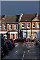
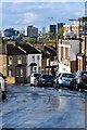
Houses in Ancona Road, just after a storm
Image: © David Martin
Taken: 3 Oct 2021
0.05 miles
2
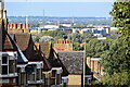
View over rooftops in Griffin Road
The building with a chimney closest to the centre of the image is at Beckton sewage treatment works, 3.5km away to the north of the River Thames.
Image: © David Martin
Taken: 3 Oct 2021
0.06 miles
3
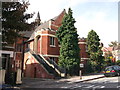
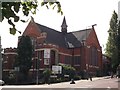
Plumstead Baptist Church
On the junction of Brewery Road (in front) and Griffin Road (unseen, on the right).
Image: © David Anstiss
Taken: 21 Aug 2011
0.06 miles
5
Plumstead Baptist Church (2)
On the junction of Brewery Road (on the left) and Griffin Road (on the right).
Image: © David Anstiss
Taken: 21 Aug 2011
0.07 miles
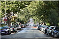
6
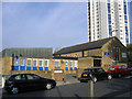
Waverley Crescent, just after heavy rain
Image: © David Martin
Taken: 3 Oct 2021
0.10 miles
7
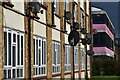
Apartments and school building, Ancona Road
Image: © David Martin
Taken: 3 Oct 2021
0.11 miles
8
St John's church & hall, Earl Rise
An Anglican parish church with attached hall.
The original church on this site was built in 1883 and demolished in 1953 after severe war damage. The present church was built within the ruined walls of the old one in 1959, using what may have been parts of the transept and chancel walls and some of the original windows. The remainder of the site was redeveloped c.1972 with the hall shown here, and housing association properties.
Image: © Stephen Craven
Taken: 5 Nov 2006
0.17 miles
9
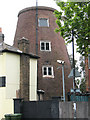
Plumstead windmill
The brick tower is the remains of an 18th century windmill. The site was an obvious one, on the top of the escarpment on the edge of Plumstead Common where it would make the most of the prevailing wind. The tower is grade 2 listed (listed building no. 200464) and appears to have been converted to residential use.
Image: © Stephen Craven
Taken: 9 May 2010
0.19 miles
10
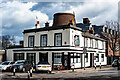
Plumstead : "The Old Mill" public house
"The pub developed from an 18th century windmill, the core of which still remains and towers over the pub building" - https://whatpub.com/pubs/SEL/10745/old-mill-plumstead.
Image: © Jim Osley
Taken: 24 Feb 2022
0.19 miles