IMAGES TAKEN NEAR TO
Pelier Street, LONDON, SE17 3JG
Introduction
This page details the photographs taken nearby to Pelier Street, SE17 3JG by members of the Geograph project.
The Geograph project started in 2005 with the aim of publishing, organising and preserving representative images for every square kilometre of Great Britain, Ireland and the Isle of Man.

There are currently over 7.5m images from over14,400 individuals and you can help contribute to the project by visiting https://www.geograph.org.uk
Image Map
Images are licensed for reuse under creativecommons.org/licenses/by-sa/2.0
Notes
- Clicking on the map will re-center to the selected point.
- The higher the marker number, the further away the image location is from the centre of the postcode.
Image Listing (170 Images Found)
Images are licensed for reuse under creativecommons.org/licenses/by-sa/2.0
Image
Details
Distance
1
Unusual modern house, Dartford Street, Walworth, south London
The view is across Pelier Street, formerly Montpelier Street – truncated in both senses.
Image: © Robin Stott
Taken: 27 Aug 2016
0.02 miles
2
Unusual modern house, Dartford Street, Walworth, south London
The view is across Pelier Street. On the left is Dartford Street passing under a railway bridge. It turns to the right and runs east of the railway to John Ruskin Street.
Image: © Robin Stott
Taken: 27 Aug 2016
0.02 miles
3
Unusual modern house, Dartford Street, Walworth, south London
The view is across Dartford Street.
Image: © Robin Stott
Taken: 27 Aug 2016
0.02 miles
5
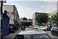
Northeast end of John Ruskin Street, Walworth, south London
Signs over the street announce Car Tyres & Wheels, We Fear No Foe – Millwall FC, … Connect Bar & Restaurant, Internet Café, Afro Tech Unisex, and a number of estate or letting agents' boards. The modern block right of centre is on the site of the Station Tavern; Walworth Road station once lay to the north. On the right, Nos.2-30 Dartford Street on the 1950s Gateway Estate Image over the border in SE17.
Image: © Robin Stott
Taken: 27 Aug 2016
0.06 miles
6
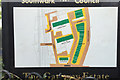
Southwark Council's plan of the Gateway Estate, Walworth, South London
As well as newly-created Gateway, Dartford Street and Empress Street are named. Maps of the early 1950s show Walworth Road extending this far south, continuing as Camberwell Road. A current A-Z shows Walworth Road ending at the north end of Gateway, marked also by the postcode boundary between SE17 to the north and SE5 to the south.
Image: © Robin Stott
Taken: 27 Aug 2016
0.06 miles
7
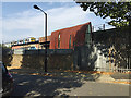
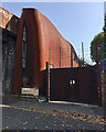
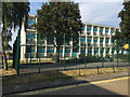
Marbles House flats, Grosvenor Terrace, Walworth, south London
Looking east towards the north end of Camberwell Road. Clubland is out of shot right Image Though more subdued, the colouring echoes that of the Gateway maisonettes: Image The rear of the building fronts John Ruskin Street.
Image: © Robin Stott
Taken: 27 Aug 2016
0.07 miles
8
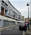
Maisonettes, 32-108 Dartford Street, Gateway Estate, Walworth, south London
Maisonettes are flats or apartments on two floors. There are three levels here, with 13 bays on each side of the building, making 78 maisonettes. 77 are numbered, so there must be the equivalent of one for other uses. There is some outside space for play and a small basketball court as well as parking.
Image: © Robin Stott
Taken: 27 Aug 2016
0.07 miles
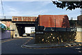
9
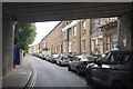
Grosvenor Terrace, Walworth, south London
The view from beneath bridge 373 HHH.
Image: © Robin Stott
Taken: 27 Aug 2016
0.07 miles
10

Letterboxes, Marbles House, Grosvenor Terrace, Walworth, south London
Image: © Robin Stott
Taken: 27 Aug 2016
0.07 miles