IMAGES TAKEN NEAR TO
Angel Lane, LONDON, SE17 3FD
Introduction
This page details the photographs taken nearby to Angel Lane, SE17 3FD by members of the Geograph project.
The Geograph project started in 2005 with the aim of publishing, organising and preserving representative images for every square kilometre of Great Britain, Ireland and the Isle of Man.

There are currently over 7.5m images from over14,400 individuals and you can help contribute to the project by visiting https://www.geograph.org.uk
Image Map
Images are licensed for reuse under creativecommons.org/licenses/by-sa/2.0
Notes
- Clicking on the map will re-center to the selected point.
- The higher the marker number, the further away the image location is from the centre of the postcode.
Image Listing (226 Images Found)
Images are licensed for reuse under creativecommons.org/licenses/by-sa/2.0
Image
Details
Distance
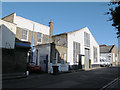
1
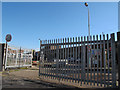
Gates to Manor Place council depot
The site will close if a proposed redevelopment of the area goes ahead (see shared description below).
Image: © Stephen Craven
Taken: 29 Apr 2015
0.00 miles
3
Buildings on the west side of Occupation Road
This side of the road is within the area currently proposed for redevelopment. This modern single-storey building appears to be one of the many sites of St Mungos Broadway (a charity for the homeless).
Image: © Stephen Craven
Taken: 29 Apr 2015
0.01 miles
4
Buildings on the east side of Occupation Road
Just outside the area currently proposed for redevelopment.
Image: © Stephen Craven
Taken: 29 Apr 2015
0.02 miles
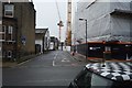
5
Occupation Road, Walworth
A dead-end road of Manor Place leading to the council recycling centre and a few small businesses.
Image: © Stephen Craven
Taken: 29 Apr 2015
0.02 miles
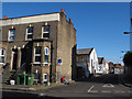
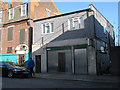
6
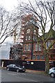
Disused building on the corner of Occupation Road
This three-storey brick building on the corner of Occupation Road and Manor Place has a prominent date - 1899 - but as of 2015 was abandoned, one of many buildings that would be demolished if a current planning application for the Manor Place develompent goes ahead.
Image: © Stephen Craven
Taken: 29 Apr 2015
0.03 miles
7
Manor Place council depot
The site will close if a proposed redevelopment of the area goes ahead (see shared description below). The viaduct in the background, which crosses the middle of the council site, is the main "Thameslink" railway south from Blackfriars.
Image: © Stephen Craven
Taken: 29 Apr 2015
0.03 miles
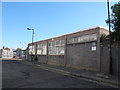
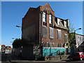
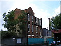
8
Derelict building on Manor Place
More modern and less architecturally interesting than its immediate neighbour Image but both are likely to be demolished to make way for a new development (see below). It had most recently been used by a Christian organisation of some sort.
Image: © Stephen Craven
Taken: 29 Apr 2015
0.03 miles
9
Derelict Building at junction of Manor Place and Occupation Road
Image: © PAUL FARMER
Taken: 16 Aug 2009
0.03 miles