IMAGES TAKEN NEAR TO
Penrose Street, LONDON, SE17 3DW
Introduction
This page details the photographs taken nearby to Penrose Street, SE17 3DW by members of the Geograph project.
The Geograph project started in 2005 with the aim of publishing, organising and preserving representative images for every square kilometre of Great Britain, Ireland and the Isle of Man.

There are currently over 7.5m images from over14,400 individuals and you can help contribute to the project by visiting https://www.geograph.org.uk
Image Map
Images are licensed for reuse under creativecommons.org/licenses/by-sa/2.0
Notes
- Clicking on the map will re-center to the selected point.
- The higher the marker number, the further away the image location is from the centre of the postcode.
Image Listing (251 Images Found)
Images are licensed for reuse under creativecommons.org/licenses/by-sa/2.0
Image
Details
Distance
1
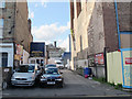
Martara Mews, Penrose Street, Walworth
Home to Boyson Cars and Luca's garage at present. Behind is a glimpse of the chimney of the old bath-house Image All this is subject to redevelopment.
Image: © Stephen Craven
Taken: 29 Apr 2015
0.02 miles
2
Former sorting office, Penrose Street, Walworth
At the time of this photo the building was being refurbished. The Royal Mail delivery office is now on nearby Crampton Street Image
Image: © Stephen Craven
Taken: 29 Apr 2015
0.02 miles
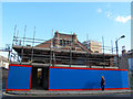
3
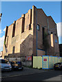
Large brick building on Penrose Street, Walworth
This building occupied the site of the former St John's Methodist chapel (see shared description below).
It was built as a scenic painting studio and consists of two separate studios each equipped with four paint frames upon which scenery was painted. The frames were counterweighted and descended through the floor so that the artist did not have to use ladders. Many west end shows were painted there. In the 1960s the building was shared by two companies: Stage Décor whose HQ was in Browning Hall in Browning street nearby, and Vic Mara Scenery. [information supplied by Neville Kersey]
It was itself under threat of demolition by 2015 as part of a proposed redevelopment.
Image: © Stephen Craven
Taken: 29 Apr 2015
0.02 miles
4
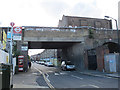
Railway viaduct over Penrose Street
The bridge is part of the "Thameslink" viaduct running south from Blackfriars. This arch has obviously been rebuild with a flat concrete soffit, presumably after being damaged by the same bomb that destroyed the adjacent power station Image Unusually there is no height warning shown.
The view also shows a bus stop and telephone box.
Image: © Stephen Craven
Taken: 29 Apr 2015
0.03 miles
5
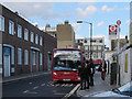
Bus stop in Penrose Street
The bus is a P5 to Brixton.
Image: © Stephen Craven
Taken: 29 Apr 2015
0.03 miles
6
Southern end of Penton Place, Walworth
No entry except for cycles.
Image: © Stephen Craven
Taken: 29 Apr 2015
0.04 miles
7
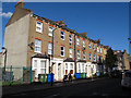
Houses on the east side of Penton Place, Walworth
Older than the Pasley Estate across the road Image and catching the evening sunshine.
Image: © Stephen Craven
Taken: 29 Apr 2015
0.04 miles
8
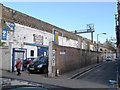
Penrose Grove, Walworth
Some of the arches of the adjacent Thameslink railway viaduct are used by a MOT centre.
Image: © Stephen Craven
Taken: 29 Apr 2015
0.04 miles
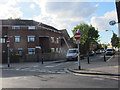
9
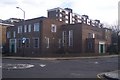
Surrey Gardens Memorial Hall
On Penrose Street, near the junction for Sturgeon Road. Penrose Grove is in the background.
Image: © David Anstiss
Taken: 27 Nov 2009
0.04 miles
10
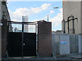
Former council depot entrance, Penrose Street, Walworth
One of the several entrances to the council site, now closed pending redevelopment. The Strata Tower is visible in the distance.
Image: © Stephen Craven
Taken: 29 Apr 2015
0.04 miles