1
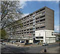
10-storey Wendover flats facing Thurlow Street, Aylesbury Estate, Walworth, London
This block is about 250m long. Behind the camera is the southernmost of the Wendover slabs, the highest at 14 storeys: see Julian Osley's
Image The Aylesbury Estate is magnificent cityscape on a vast scale but in detail is not appealing. Nevertheless for thousands of families it is home.
Image: © Robin Stott
Taken: 5 Apr 2016
0.01 miles
2
Wendover House, Thurlow Street
The Aylesbury Estate's largest 'barrier' block. Pevsner reports that, according to the Guinness Book of Records, it is "the longest block in Europe built to an industrialised system".
Catch it while you can - it is due to be pulled down, a process which is likely to increase its resemblance to the town in Buckinghamshire.
Image: © Stephen Richards
Taken: 6 May 2013
0.03 miles
3
Wendover, Thurlow Street, SE17
Wendover is part of the Aylesbury Estate. The estate is a good case study in how not to build council housing.
Image: © Danny P Robinson
Taken: 14 Jan 2007
0.04 miles
4
Chimney, Beaconsfield Road
On the Aylesbury Estate.
Image: © Stephen Richards
Taken: 6 May 2013
0.05 miles
5
Thurlow Street, Walworth
Part of the Aylesbury estate that had not yet been demolished, this is on the west side of Thurlow Street and including what I presume is the district heating centre with its tall chimney.
Image: © Stephen Craven
Taken: 3 Jul 2014
0.05 miles
6
Neighbourhood shop, corner of Alvey Street and Surrey Grove, Walworth
On the corner of Alvey Street and Surrey Grove, Grove Food & Wine appears a thriving business. Before World War II Alvey Street showed on maps as an artery to and from central London. Now it and Surrey Grove are stubs on the edge of the Aylesbury Estate. Two of the blocks in the Wolverton group are on the left.
Image: © Robin Stott
Taken: 5 Apr 2016
0.05 miles
7
The Hour Glass Hotel, Walworth
A budget accommodation on Beaconsfield Road. Seen from Thurlow Street.
Image: © David Anstiss
Taken: 27 Nov 2009
0.05 miles
8
Wolverton low-rise blocks by Alvey Street, Aylesbury Estate, Walworth
Beyond them is the long 10-storey Wendover block. The view is from Surrey Square Park.
Image: © Robin Stott
Taken: 5 Apr 2016
0.05 miles
9
West on Kinglake Street, Walworth
On the left is part of Faversham House, most westerly block of the post-war Kinglake Estate. On the right, the edge of Surrey Square Park. Down the street is the 14-storey cliff that is the southernmost Wendover block of the Aylesbury Estate. One of the low-rise Wolverton blocks juts in from the right, closer at hand. This view is roughly the reverse of
Image
Image: © Robin Stott
Taken: 5 Apr 2016
0.06 miles
10
Hour Glass Hotel
Image: © N Chadwick
Taken: 3 Feb 2018
0.06 miles


