IMAGES TAKEN NEAR TO
Bagshot Street, LONDON, SE17 2QW
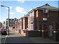
Introduction
This page details the photographs taken nearby to Bagshot Street, SE17 2QW by members of the Geograph project.
The Geograph project started in 2005 with the aim of publishing, organising and preserving representative images for every square kilometre of Great Britain, Ireland and the Isle of Man.

There are currently over 7.5m images from over14,400 individuals and you can help contribute to the project by visiting https://www.geograph.org.uk
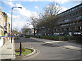
Image Map
Images are licensed for reuse under creativecommons.org/licenses/by-sa/2.0
Notes
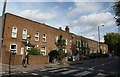
- Clicking on the map will re-center to the selected point.
- The higher the marker number, the further away the image location is from the centre of the postcode.
Image Listing (174 Images Found)
Images are licensed for reuse under creativecommons.org/licenses/by-sa/2.0
Image
Details
Distance
1
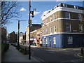
Junction of Bagshot Street and Mina Road, Walworth
These streets are shown on a map of 1851, though Bagshot Street was called York Road. Behind the camera and left is the Ravenstone block of the Aylesbury Estate, its easternmost extent.
Image: © Robin Stott
Taken: 5 Apr 2016
0.01 miles
2
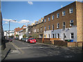
South side of Mina Road, Walworth
Housing of mixed ages in Mina Road. Down the street are old and new parts of Walworth Academy.
Image: © Robin Stott
Taken: 5 Apr 2016
0.03 miles
3
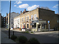
Corner of Bagshot Street and Smyrk's Road, Walworth
These streets are shown on a map of 1851, though Bagshot Street was called Yprk Road. Behind the camera and left is the Ravenstone block of the Aylesbury Estate, its easternmost extent.
Image: © Robin Stott
Taken: 5 Apr 2016
0.03 miles
4
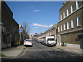
Smyrk's Road, Walworth
The road is shown on a map of 1851. A map of 1875 shows the housing. There's every indication that it was like this, across a wide area, when there was far more employment south of the river than there is now. Behind the camera is the Ravenstone block of the Aylesbury Estate, its easternmost extent. https://southwarknotes.wordpress.com
Image: © Robin Stott
Taken: 5 Apr 2016
0.04 miles
6
Bagshot Street and the Ravenstone block of the Aylesbury Estate, Walworth
This is the easternmost extent of the Aylesbury Estate, which is to be regenerated over a long period. In 1851 Bagshot Street was called York Road.
Image: © Robin Stott
Taken: 5 Apr 2016
0.04 miles
7
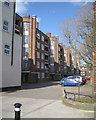
Rear of Keston House, Kinglake Estate, Walworth
The round structures appear to be stair towers with ventilated rubbish chutes. These council flats were probably built in the late 1940s. On the left is a corner convenience store, formerly a pub, retained from the earlier townscape.
Image: © Robin Stott
Taken: 5 Apr 2016
0.05 miles
8
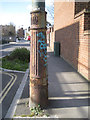
Base of sewer vent pipe, Bagshot Street, Walworth
The name Bagshot Street is first shown on a map of 1875, though in 1851 it was shown as York Road. Bagshot Street runs between busy Albany Road and Kinglake Street.
Image: © Robin Stott
Taken: 5 Apr 2016
0.06 miles
9
Terrace on Albany Road, SE5
A terrace of 12 properties on the north side of the B214.
Image: © Derek Harper
Taken: 17 Oct 2011
0.07 miles
10
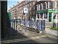
Steel railings, Southborough House frontage, Kinglake Street, Walworth
Across the road is the plain front of Keston House; the rear is seen in Image The convenience store on the corner of Bagshot Street may once have been a pub, retained in the development of the Kinglake Estate after the war.
Image: © Robin Stott
Taken: 5 Apr 2016
0.07 miles