IMAGES TAKEN NEAR TO
Bagshot Street, LONDON, SE17 2QT
Introduction
This page details the photographs taken nearby to Bagshot Street, SE17 2QT by members of the Geograph project.
The Geograph project started in 2005 with the aim of publishing, organising and preserving representative images for every square kilometre of Great Britain, Ireland and the Isle of Man.

There are currently over 7.5m images from over14,400 individuals and you can help contribute to the project by visiting https://www.geograph.org.uk
Image Map
Images are licensed for reuse under creativecommons.org/licenses/by-sa/2.0
Notes
- Clicking on the map will re-center to the selected point.
- The higher the marker number, the further away the image location is from the centre of the postcode.
Image Listing (171 Images Found)
Images are licensed for reuse under creativecommons.org/licenses/by-sa/2.0
Image
Details
Distance
1
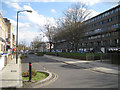
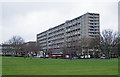
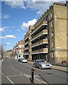
Bagshot Street and the Ravenstone block of the Aylesbury Estate, Walworth
This is the easternmost extent of the Aylesbury Estate, which is to be regenerated over a long period. In 1851 Bagshot Street was called York Road.
Image: © Robin Stott
Taken: 5 Apr 2016
0.02 miles
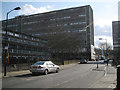
3
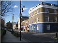
Junction of Bagshot Street and Mina Road, Walworth
These streets are shown on a map of 1851, though Bagshot Street was called York Road. Behind the camera and left is the Ravenstone block of the Aylesbury Estate, its easternmost extent.
Image: © Robin Stott
Taken: 5 Apr 2016
0.05 miles
5
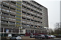
Wendover block, Aylesbury Estate, Walworth
One of the blocks that make up the Aylesbury Estate at Walworth. For an account of this estate and the controversial attempts at regeneration see this https://municipaldreams.wordpress.com/2014/01/07/the-aylesbury-estate-southwark-where-all-that-is-left-of-the-high-hopes-of-the-post-war-planners-is-derelict-concrete/.
Image: © Jim Osley
Taken: 22 Feb 2017
0.06 miles
6
Winslow, Wendover and Wolverten, Aylesbury Estate, Walworth
The view is west at the kink on Kinglake Road, roughly the reverse of Image The names of blocks are not suffixed with House as on the post-war Kinglake Estate behind the camera. To the left is low-rise Winslow. Rearing up behind it is 14-storey Wendover. One of the Wolverton blocks juts in from the right. The blue sheeting is for the demolition or refurbishment of Latimer on the other side of Thurlow Street. Note all the plastic bags caught in the tree.
Image: © Robin Stott
Taken: 5 Apr 2016
0.06 miles
9
Faversham House, Kinglake Street, Walworth
Beyond the corner shop at the Bagshot Street junction are two other blocks of the Kinglake Estate, Keston House and Amery House. This view is roughly the reverse of Image and Image
Image: © Robin Stott
Taken: 5 Apr 2016
0.06 miles
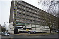
10
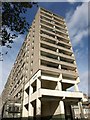
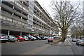
Wendover, SE17
Also shown in Image This is the southeastern block seen from Albany Road. There seem to be 230 flats here.
Image: © Derek Harper
Taken: 17 Oct 2011
0.06 miles