IMAGES TAKEN NEAR TO
Inville Road, LONDON, SE17 2HT
Introduction
This page details the photographs taken nearby to Inville Road, SE17 2HT by members of the Geograph project.
The Geograph project started in 2005 with the aim of publishing, organising and preserving representative images for every square kilometre of Great Britain, Ireland and the Isle of Man.

There are currently over 7.5m images from over14,400 individuals and you can help contribute to the project by visiting https://www.geograph.org.uk
Image Map
Images are licensed for reuse under creativecommons.org/licenses/by-sa/2.0
Notes
- Clicking on the map will re-center to the selected point.
- The higher the marker number, the further away the image location is from the centre of the postcode.
Image Listing (131 Images Found)
Images are licensed for reuse under creativecommons.org/licenses/by-sa/2.0
Image
Details
Distance
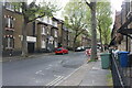
1
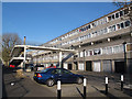
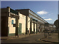
Inville Road, Walworth
Villa Street runs north-south for about 400 metres through Walworth, and along its length can be seen a variety of housing from the mid-19th to late 20th century.
Heading south, there is an abrupt change from pre- to post-war housing at the junction with Inville Street (which actually functions as a back street for resident access, rather than a through route). The footbridge gives access to the rear door of a housing block at second floor level. From here south to Albany Road is the Aylesbury Estate.
Image: © Stephen Craven
Taken: 14 Apr 2015
0.02 miles
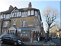
2
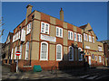
Villa Street medical centre, Walworth
Villa Street runs north-south for about 400 metres through Walworth, and along its length can be seen a variety of housing from the mid-19th to late 20th century.
This striking building, 47 Villa Street on the corner of Merrow Street, is an Edwardian building (c.1906) and originally formed part of the Church Commissioners' Octavia Hill Estate. At various times it has been a mother and child clinic, a refuge, a depot and a squat, but most recently converted in 2003 by Avanti Architects into a medical centre. Cycle stands are provided for clients. Source: http://webarchive.nationalarchives.gov.uk/20110118095356/http://www.cabe.org.uk/case-studies/villa-street-medical-centre/design
Image: © Stephen Craven
Taken: 14 Apr 2015
0.04 miles
3
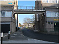
Southern part of Villa Street, Walworth
Villa Street runs north-south for about 400 metres through Walworth, and along its length can be seen a variety of housing from the mid-19th to late 20th century.
Heading south, there is an abrupt change from pre- to post-war housing at the junction with Inville Street. This is looking south under a footbridge linking two housing blocks at second floor level.
Image: © Stephen Craven
Taken: 14 Apr 2015
0.05 miles
4
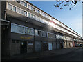
Roland Way, Walworth
This five-storey block of flats forms a barrier between the post-war housing along Albany Road and older housing to the north.
Image: © Stephen Craven
Taken: 14 Apr 2015
0.05 miles
6
Merrow Street, Walworth
Villa Street runs north-south for about 400 metres through Walworth, and along its length can be seen a variety of housing from the mid-19th to late 20th century.
These houses on Merrow Street at the junction with Villa Street bear the date 1906 placing them firmly in the Edwardian era.
Image: © Stephen Craven
Taken: 14 Apr 2015
0.07 miles
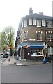
8
Merrow Street Stores, Walworth
Villa Street runs north-south for about 400 metres through Walworth, and along its length can be seen a variety of housing from the mid-19th to late 20th century.
This is a convenience store on the corner of Merrow Street.
Image: © Stephen Craven
Taken: 14 Apr 2015
0.07 miles
9
Inville Road, Walworth
A side street off Thurlow Road Image, part of the Aylesbury estate that had not yet been demolished.
Image: © Stephen Craven
Taken: 3 Jul 2014
0.08 miles
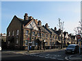
10
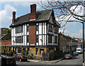
126 Dawes Street
Formerly the Queen Anne pub, Brewers' Tudor inappopriately.
Now flats staring at the Aylesbury Estate.
Image: © Stephen Richards
Taken: 6 May 2013
0.09 miles