IMAGES TAKEN NEAR TO
Westmoreland Road, LONDON, SE17 2DA
Introduction
This page details the photographs taken nearby to Westmoreland Road, SE17 2DA by members of the Geograph project.
The Geograph project started in 2005 with the aim of publishing, organising and preserving representative images for every square kilometre of Great Britain, Ireland and the Isle of Man.

There are currently over 7.5m images from over14,400 individuals and you can help contribute to the project by visiting https://www.geograph.org.uk
Image Map
Images are licensed for reuse under creativecommons.org/licenses/by-sa/2.0
Notes
- Clicking on the map will re-center to the selected point.
- The higher the marker number, the further away the image location is from the centre of the postcode.
Image Listing (168 Images Found)
Images are licensed for reuse under creativecommons.org/licenses/by-sa/2.0
Image
Details
Distance
1
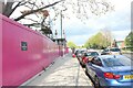
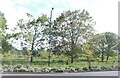
Albany Road, Walworth
They are currently replacing a large council estate on the left which isn't very old itself. Burgess Park is on the right.
Image: © David Howard
Taken: 24 Apr 2024
0.01 miles
2
Chilton House
Seen from within Burgess Park. See Image for a different perspective.
Image: © Stephen Craven
Taken: 21 Oct 2014
0.02 miles
3
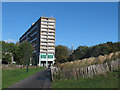
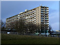
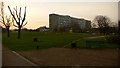
Aylesbury Estate, from Burgess Park
This photograph was taken in Burgess Park, in inner South London, looking north at one of the blocks of flats in the Aylesbury Estate.
The Aylesbury Estate was built in the early 1970s, but is due to be regenerated over the coming years.
Image: © Malc McDonald
Taken: 7 Mar 2015
0.02 miles
4
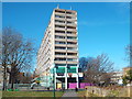
Albany Road, SE5
Albany Road near Camberwell in inner south London.
The tower block is part of the Aylesbury Estate, built in the early 1970s. The estate is due to be regenerated over the years ahead.
In the far distance, the towers of Canary Wharf are just visible.
Image: © Malc McDonald
Taken: 7 Mar 2015
0.02 miles
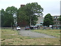
6
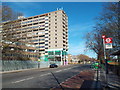
Chilton House, Southwark
A block of Southwark Council offices on Portland Street, seen across Burgess Park.
Image: © Stephen Craven
Taken: 1 Feb 2014
0.03 miles
7
Burgess Adventure Playground, Albany Road (B214)
Image: © Noel Foster
Taken: 10 Oct 2005
0.05 miles
8
Canal Street, SE5
Canal Street, as its name suggests, once led to a canal. The canal has been filled in, and the streets, houses and industrial buildings which surrounded it have been demolished. Burgess Park, which is a large park, has been created on the site.
Canal Street itself was one of several roads within Burgess Park which had been closed, but not removed. The park is due to receive a major facelift in 2011 and into 2012. This will include removing most of the abandoned roads within the park.
In the background are flats belonging to the Aylesbury Estate, a large council estate built in the 1960s and early 1970s. This estate is starting to undergo a major regeneration programme which will take a number of years to complete.
Image: © Malc McDonald
Taken: 29 May 2011
0.07 miles
9
Burgess Park
Burgess Park in South London, 60's town planners finishing off the Luftwaffe's ground work.
Image: © geo sharples
Taken: 4 Feb 2007
0.07 miles
10
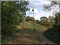
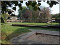
Burgess Park
A forgotten corner of the park west of Wells Way.
Image: © Derek Harper
Taken: 17 Oct 2011
0.08 miles