IMAGES TAKEN NEAR TO
SE17 1ZG
Introduction
This page details the photographs taken nearby to SE17 1ZG by members of the Geograph project.
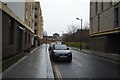
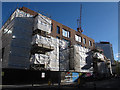
The Geograph project started in 2005 with the aim of publishing, organising and preserving representative images for every square kilometre of Great Britain, Ireland and the Isle of Man.

There are currently over 7.5m images from over14,400 individuals and you can help contribute to the project by visiting https://www.geograph.org.uk
Image Map
Images are licensed for reuse under creativecommons.org/licenses/by-sa/2.0
Notes
- Clicking on the map will re-center to the selected point.
- The higher the marker number, the further away the image location is from the centre of the postcode.
Image Listing (228 Images Found)
Images are licensed for reuse under creativecommons.org/licenses/by-sa/2.0
Image
Details
Distance
1
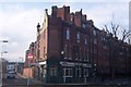
The Rose and Crown Public House, Walworth
On the junction of Wadding Street (on the right) and Rodney Street (on the left).
Image: © David Anstiss
Taken: 27 Nov 2009
0.02 miles
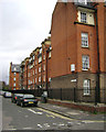
2
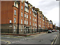
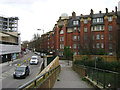
Peabody Trust flats, Walworth, Wadding Street frontage
The Walworth Estate first appears as Peabody Buildings on the Ordnance Survey map of 1914-21. It replaced cramped terraced houses. It's interesting that the spectacular Heygate Estate to the northwest, which appears to date from the early 1970s, is being demolished and redeveloped; Peabody housing has outlasted it. A frontal view is Image
Image: © Robin Stott
Taken: 9 Feb 2014
0.03 miles
3
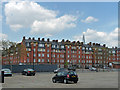
Peabody Estate, Wadding Street
Dated 1915.
Closer view: Image
Note the omni-present Shard. I believe the car park has since been turned into flats.
Image: © Stephen Richards
Taken: 6 May 2013
0.03 miles
4
Trafalgar Place under construction (1)
New housing going up on a triangular site in Walworth.
Image: © Stephen Craven
Taken: 21 Oct 2014
0.04 miles
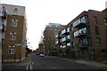
5
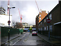
Looking east on Larcom Street to the Trafalgar Place development, Walworth
After a short sharp shower. The view is across Rodney Road at the end.
Image: © Robin Stott
Taken: 8 Feb 2014
0.04 miles
6
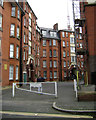
Peabody Trust flats, Walworth, courtyard off Content Street
The Walworth Estate first appears as Peabody Buildings on the Ordnance Survey map of 1914-21. It replaced cramped terraced houses. It's interesting that the spectacular Heygate Estate to the northwest, which appears to date from the early 1970s, is being demolished and redeveloped; Peabody housing has outlasted it.
Image: © Robin Stott
Taken: 9 Feb 2014
0.04 miles
7
Peabody Trust flats, Walworth, Rodney Street frontage
The Walworth Estate first appears as Peabody Buildings on the Ordnance Survey map of 1914-21. It replaced cramped terraced houses. It's interesting that the spectacular Heygate Estate to the northwest, which appears to date from the early 1970s, is being demolished and redeveloped; Peabody housing has outlasted it.
This view is the reverse of Image
Image: © Robin Stott
Taken: 9 Feb 2014
0.04 miles
8
Peabody Trust flats, Walworth, Content Street frontage
The Walworth Estate first appears as Peabody Buildings on the Ordnance Survey map of 1914-21. It replaced cramped terraced houses. It's interesting that the spectacular Heygate Estate to the northwest, which appears to date from the early 1970s, is being demolished and redeveloped; Peabody housing has outlasted it.
Image: © Robin Stott
Taken: 9 Feb 2014
0.04 miles
9
Balfour Street
Looking across the junction with Henshaw Street.
Image: © DS Pugh
Taken: 9 Dec 2016
0.05 miles