IMAGES TAKEN NEAR TO
Comus Place, LONDON, SE17 1TQ
Introduction
This page details the photographs taken nearby to Comus Place, SE17 1TQ by members of the Geograph project.
The Geograph project started in 2005 with the aim of publishing, organising and preserving representative images for every square kilometre of Great Britain, Ireland and the Isle of Man.

There are currently over 7.5m images from over14,400 individuals and you can help contribute to the project by visiting https://www.geograph.org.uk
Image Map (Loading...)


Getting Data...Please wait
Leaflet Map data © OpenStreetMap
Images are licensed for reuse under creativecommons.org/licenses/by-sa/2.0
Notes
- Clicking on the map will re-center to the selected point.
- The higher the marker number, the further away the image location is from the centre of the postcode.
Image Listing (168 Images Found)
Images are licensed for reuse under creativecommons.org/licenses/by-sa/2.0
Image
Details
Distance
1
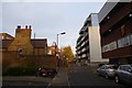
Townsend Street
Looking along a pedestrianised street leading to the Old and New Kent Roads.
Image: © DS Pugh
Taken: 9 Dec 2016
0.02 miles
2
Victory House, 5 Congreve Street, SE17
This is a branch of The Redeemed Christian Church of God, a Christian denomination with its roots in Nigeria. Here is a link to their website http://home.rccg.org/home.html
Image: © Danny P Robinson
Taken: 8 Jun 2007
0.05 miles
3
Preston Close, SE1
A cul-de-sac just off the Old Kent Road.
Image: © Danny P Robinson
Taken: 8 Jun 2007
0.05 miles
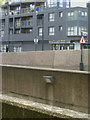
4
Old Kent Road approaching Bricklayers Arms
At the junction with Preston Close. Note the speed camera calibration marks in the foreground.
Image: © Danny P Robinson
Taken: 8 Jun 2007
0.05 miles
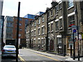
5
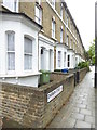
Terraced houses in Darwin Street Bermondsey
Image: © Rod Allday
Taken: 10 Sep 2016
0.05 miles
6
Old Kent Road
Concrete jungle: the walls in the foreground are part of the Bricklayers Arms flyover, built in the 1970s, which brings traffic from the New Kent Road to the Old Kent Road. On the other side is Augustus Court.
Image: © Stephen McKay
Taken: 30 Apr 2012
0.07 miles
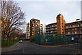
7
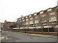
Tatum Street, Walworth
The architecture of these two mid-20th century housing blocks (Povey House, foreground, and Ellery House beyond) contrasts with the Pembroke College Mission across the road Image
Image: © Stephen Craven
Taken: 10 Mar 2012
0.07 miles
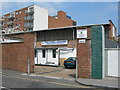
8
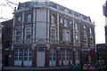
Was the Victory Public House
Pub converted into apartments. On the junction of Barlow Street (in front) and Catesby Street (on the right).
Image: © David Anstiss
Taken: 27 Nov 2009
0.07 miles
9
Catesby Street
Looking along Catesby Street with a park on the left.
Image: © DS Pugh
Taken: 9 Dec 2016
0.07 miles
10
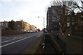
Old Kent Road
Looking along Old Kent Road from Townsend Street.
Image: © DS Pugh
Taken: 9 Dec 2016
0.08 miles