IMAGES TAKEN NEAR TO
Elba Place, LONDON, SE17 1PT
Introduction
This page details the photographs taken nearby to Elba Place, SE17 1PT by members of the Geograph project.
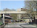
The Geograph project started in 2005 with the aim of publishing, organising and preserving representative images for every square kilometre of Great Britain, Ireland and the Isle of Man.

There are currently over 7.5m images from over14,400 individuals and you can help contribute to the project by visiting https://www.geograph.org.uk
Image Map
Images are licensed for reuse under creativecommons.org/licenses/by-sa/2.0
Notes
- Clicking on the map will re-center to the selected point.
- The higher the marker number, the further away the image location is from the centre of the postcode.
Image Listing (306 Images Found)
Images are licensed for reuse under creativecommons.org/licenses/by-sa/2.0
Image
Details
Distance
1
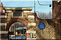
Victory Primary School
Viewed from an elevated walkway of the derelict Heygate Estate. This huge estate of multi-storey flats must have supplied a large proportion of the pupils here.
Image: © Robin Webster
Taken: 23 Jul 2011
0.02 miles
2
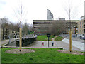
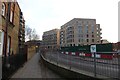
Ball games area, Victory Community Park, Walworth
The L-shaped park takes its name from Victory Place at its southeast corner. It adjoins Victory Primary School, Elba Place. In view here are a slab of the Heygate Estate, vacated and awaiting demolition, with the Strata Tower at Elephant and Castle beyond it. On the right is Munton Road.
Image: © Robin Stott
Taken: 9 Feb 2014
0.02 miles
3
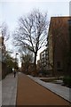
Victory Place
Looking along the pedestrianised Victory Place off Rodney Road.
Image: © DS Pugh
Taken: 9 Dec 2016
0.03 miles
4

Rodney Road, SE17
Rodney Road passes through the Heygate Estate in inner South London. The estate was built in the 1970s and once housed 3,000 people. It is due for demolition.
This scene will look very different in a few years' time. The bridge over the road was removed in May 2011, a few weeks after this picture was taken, while the large block of flats in the background will also be pulled down.
Image: © Malc McDonald
Taken: 8 Apr 2011
0.03 miles
5
Rodney Road, SE17
Rodney Road passes through the Heygate Estate in inner South London. The estate was built in the 1970s and once housed 3,000 people. It is due for demolition. This scene will look very different in a few years' time.
The bridge over the road was removed in May 2011, a few weeks after this picture was taken.
Image: © Malc McDonald
Taken: 8 Apr 2011
0.03 miles
6
Rodney Road
Looking along Rodney Road. On the right Elephant Park is under construction.
Image: © DS Pugh
Taken: 9 Dec 2016
0.04 miles
7
House at corner of Victory School grounds
Possibly a caretaker's house originally, but it looks a bit big for that.
Image: © Robin Webster
Taken: 23 Jul 2011
0.04 miles
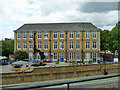
9
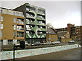
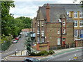
Morant Court, 5 Munton Road, Walworth
This is the front block of two. The view is from Victory Community Park.
Image: © Robin Stott
Taken: 8 Feb 2014
0.04 miles