IMAGES TAKEN NEAR TO
Brandon Street, LONDON, SE17 1DY
Introduction
This page details the photographs taken nearby to Brandon Street, SE17 1DY by members of the Geograph project.
The Geograph project started in 2005 with the aim of publishing, organising and preserving representative images for every square kilometre of Great Britain, Ireland and the Isle of Man.

There are currently over 7.5m images from over14,400 individuals and you can help contribute to the project by visiting https://www.geograph.org.uk
Image Map
Images are licensed for reuse under creativecommons.org/licenses/by-sa/2.0
Notes
- Clicking on the map will re-center to the selected point.
- The higher the marker number, the further away the image location is from the centre of the postcode.
Image Listing (230 Images Found)
Images are licensed for reuse under creativecommons.org/licenses/by-sa/2.0
Image
Details
Distance
1
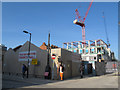
English Martyrs Church Hall (temporary)
The parish hall of this Roman Catholic parish was being replaced as part of a wider redevelopment of the Walworth area. The former parish hall was closed in 2013 and this temporary hall provided in Stead Street on what was a car park. The permanent new parish hall will form the ground floor of a new development on the original site, to be completed by the summer of 2015.
source: http://carmelite.org/index.php?nuc=news&func=view&item=689
Image: © Stephen Craven
Taken: 14 Apr 2015
0.01 miles
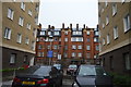
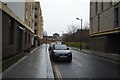
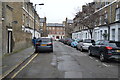
4
Peabody Estate, Wadding Street
Dated 1915.
Closer view: Image
Note the omni-present Shard. I believe the car park has since been turned into flats.
Image: © Stephen Richards
Taken: 6 May 2013
0.03 miles
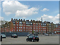
7
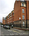
Peabody Trust flats, Walworth, Content Street frontage
The Walworth Estate first appears as Peabody Buildings on the Ordnance Survey map of 1914-21. It replaced cramped terraced houses. It's interesting that the spectacular Heygate Estate to the northwest, which appears to date from the early 1970s, is being demolished and redeveloped; Peabody housing has outlasted it.
Image: © Robin Stott
Taken: 9 Feb 2014
0.04 miles
8
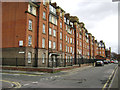
Peabody Trust flats, Walworth, Wadding Street frontage
The Walworth Estate first appears as Peabody Buildings on the Ordnance Survey map of 1914-21. It replaced cramped terraced houses. It's interesting that the spectacular Heygate Estate to the northwest, which appears to date from the early 1970s, is being demolished and redeveloped; Peabody housing has outlasted it. A frontal view is Image
Image: © Robin Stott
Taken: 9 Feb 2014
0.04 miles
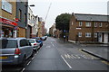
10
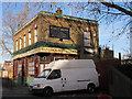
The Crown, Brandon Street
This is the only remaining original building on the east side of Brandon Street. It looked still to be open as of the end of 2011.
Image: © Stephen Craven
Taken: 10 Dec 2011
0.05 miles