IMAGES TAKEN NEAR TO
Rodney Road, LONDON, SE17 1AT
Introduction
This page details the photographs taken nearby to Rodney Road, SE17 1AT by members of the Geograph project.
The Geograph project started in 2005 with the aim of publishing, organising and preserving representative images for every square kilometre of Great Britain, Ireland and the Isle of Man.

There are currently over 7.5m images from over14,400 individuals and you can help contribute to the project by visiting https://www.geograph.org.uk
Image Map
Images are licensed for reuse under creativecommons.org/licenses/by-sa/2.0
Notes
- Clicking on the map will re-center to the selected point.
- The higher the marker number, the further away the image location is from the centre of the postcode.
Image Listing (236 Images Found)
Images are licensed for reuse under creativecommons.org/licenses/by-sa/2.0
Image
Details
Distance
1
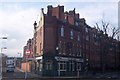
The Rose and Crown Public House, Walworth
On the junction of Wadding Street (on the right) and Rodney Street (on the left).
Image: © David Anstiss
Taken: 27 Nov 2009
0.02 miles
2
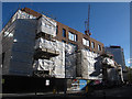
Trafalgar Place under construction (1)
New housing going up on a triangular site in Walworth.
Image: © Stephen Craven
Taken: 21 Oct 2014
0.03 miles
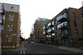
3
Looking east on Larcom Street to the Trafalgar Place development, Walworth
After a short sharp shower. The view is across Rodney Road at the end.
Image: © Robin Stott
Taken: 8 Feb 2014
0.03 miles
4
Balfour Street
Looking across the junction with Henshaw Street.
Image: © DS Pugh
Taken: 9 Dec 2016
0.03 miles
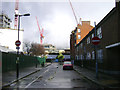
5
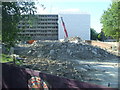
Heygate Estate demolition
The demolition of the Heygate Estate in inner south London is part of a £1.5billion project which will take a number of years to complete. This is the first part of the estate to be demolished, seen from the upper deck of a bus on Rodney Road.
Image: © Malc McDonald
Taken: 2 May 2011
0.03 miles
6
Church of the Sacred Order of the Cherubim and Seraphim
Image: © N Chadwick
Taken: 3 Feb 2018
0.04 miles
7
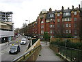
Peabody Trust flats, Walworth, Rodney Street frontage
The Walworth Estate first appears as Peabody Buildings on the Ordnance Survey map of 1914-21. It replaced cramped terraced houses. It's interesting that the spectacular Heygate Estate to the northwest, which appears to date from the early 1970s, is being demolished and redeveloped; Peabody housing has outlasted it.
This view is the reverse of Image
Image: © Robin Stott
Taken: 9 Feb 2014
0.04 miles
8
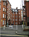
Peabody Trust flats, Walworth, courtyard off Content Street
The Walworth Estate first appears as Peabody Buildings on the Ordnance Survey map of 1914-21. It replaced cramped terraced houses. It's interesting that the spectacular Heygate Estate to the northwest, which appears to date from the early 1970s, is being demolished and redeveloped; Peabody housing has outlasted it.
Image: © Robin Stott
Taken: 9 Feb 2014
0.04 miles
9

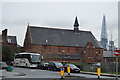
The Mount of Salvation Cathedral
This brick building on Chatham Street, Walworth, with an apsidal east end, is now a church of the denomination "Cherubim and Seraphim". See Image for another view.
It is listed grade 2 (list entry number 1378475) under its former name, Lady Margaret Church. It was built in 1889 as an Anglican mission, the architect being E Christian. As a parish church it was considered for closure from 1966 and the parish was united with that of St John in 1975 when it became a Chapel of Ease. It was finally declared redundant in 1983 and used from 1986 by the Cherubim & Seraphim church who have leased it from the Diocese since 1990.
Image: © Stephen Craven
Taken: 10 Jan 2013
0.05 miles
10
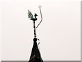
Weathercock in Walworth
The weathercock is on the fleche of the Cherubim & Seraphim church Image it is protected by a very prominent lightning conductor.
Image: © Stephen Craven
Taken: 10 Jan 2013
0.05 miles