IMAGES TAKEN NEAR TO
New Kent Road, LONDON, SE1 6TX
Introduction
This page details the photographs taken nearby to New Kent Road, SE1 6TX by members of the Geograph project.
The Geograph project started in 2005 with the aim of publishing, organising and preserving representative images for every square kilometre of Great Britain, Ireland and the Isle of Man.

There are currently over 7.5m images from over14,400 individuals and you can help contribute to the project by visiting https://www.geograph.org.uk
Image Map
Images are licensed for reuse under creativecommons.org/licenses/by-sa/2.0
Notes
- Clicking on the map will re-center to the selected point.
- The higher the marker number, the further away the image location is from the centre of the postcode.
Image Listing (290 Images Found)
Images are licensed for reuse under creativecommons.org/licenses/by-sa/2.0
Image
Details
Distance
1
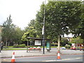
Rodney Place and the New Kent Road
Crown and Anchor pub on Rodney Place and the New Kent Road
Image: © Shaun Ferguson
Taken: 19 Feb 2008
0.02 miles
2
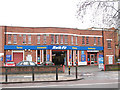
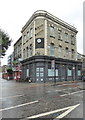
Kwik-Fit, New Kent Road
A motor repair franchise.
Image: © Stephen Craven
Taken: 20 Mar 2010
0.02 miles
3
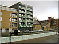
Morant Court, 5 Munton Road, Walworth
This is the front block of two. The view is from Victory Community Park.
Image: © Robin Stott
Taken: 8 Feb 2014
0.02 miles
4
Street furniture on the New Kent Road
The pavement on the north side of the New Kent Road, with waste bin, phone box, and ornamental spheres.
Image: © Stephen Craven
Taken: 20 Mar 2010
0.03 miles
5
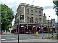
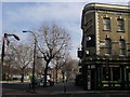
Crown and Anchor, New Kent Road
It seems to be still open, but up for sale.
Image: © Robin Webster
Taken: 23 Jul 2011
0.04 miles
6
The Crown & Anchor public house in New Kent Road at the Elephant & Castle
Image: © Rod Allday
Taken: 10 Sep 2016
0.04 miles
7
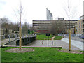
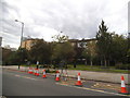
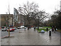
Ball games area, Victory Community Park, Walworth
The L-shaped park takes its name from Victory Place at its southeast corner. It adjoins Victory Primary School, Elba Place. In view here are a slab of the Heygate Estate, vacated and awaiting demolition, with the Strata Tower at Elephant and Castle beyond it. On the right is Munton Road.
Image: © Robin Stott
Taken: 9 Feb 2014
0.04 miles
8
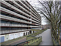
Heygate Estate, Heygate Street (4)
The eastern perimeter block, with Rodney Place on the right.
Either another monument to 1960s idealism doomed by modern tastes (now everything must glitter, concrete's just too grey - boring) and/or a mercenary council, or another concrete hell-hole past its sell-by date. Take your pick. Although planned during the previous decade, the Heygate's 1,200 flats were built in 1970-74. The four vast concrete blocks forming the perimeter are certainly forbidding ("impressive from a distance" wrote Pevsner), but the inside is surprisingly green and the spacious flats meant that for a time it was not an unpopular place to live. Later it fell victim to the usual blights and Southwark Council are, perhaps unnecessarily, demolishing the whole lot. They started earlier this year but it will take several years to finish the job. Old communities will vanish and it seems likely that most of the old occupants will be priced out of the new development.
Image: © Stephen Richards
Taken: 13 Feb 2011
0.05 miles