IMAGES TAKEN NEAR TO
Trafalgar Close, LONDON, SE16 7RL
Introduction
This page details the photographs taken nearby to Trafalgar Close, SE16 7RL by members of the Geograph project.
The Geograph project started in 2005 with the aim of publishing, organising and preserving representative images for every square kilometre of Great Britain, Ireland and the Isle of Man.

There are currently over 7.5m images from over14,400 individuals and you can help contribute to the project by visiting https://www.geograph.org.uk
Image Map
Images are licensed for reuse under creativecommons.org/licenses/by-sa/2.0
Notes
- Clicking on the map will re-center to the selected point.
- The higher the marker number, the further away the image location is from the centre of the postcode.
Image Listing (237 Images Found)
Images are licensed for reuse under creativecommons.org/licenses/by-sa/2.0
Image
Details
Distance
1
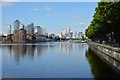
Greenland Quay
A view from the western end of Greenland Dock.
Image: © Stephen Craven
Taken: 22 May 2010
0.03 miles
6
Plough public house II (site of)
Site was Plough Road (now Plough Way), Rotherhithe, SE16 very near the junction with the Swedish Yard entrance to Surrey Docks, from 1900 to about 1961. Originally in Commercial Dock Road - see Image Site now occupied by Caronia Court, 71, Plough Way.
Image: © Chris Lordan
Taken: 17 Aug 2011
0.04 miles
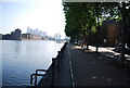
8
Cunard Walk, Rotherhithe
The path runs parallel to Greenland Dock and is presumably named after the liner company.
Image: © Stephen Craven
Taken: 19 Apr 2014
0.05 miles