IMAGES TAKEN NEAR TO
Elgar Street, LONDON, SE16 7QA
Introduction
This page details the photographs taken nearby to Elgar Street, SE16 7QA by members of the Geograph project.
The Geograph project started in 2005 with the aim of publishing, organising and preserving representative images for every square kilometre of Great Britain, Ireland and the Isle of Man.

There are currently over 7.5m images from over14,400 individuals and you can help contribute to the project by visiting https://www.geograph.org.uk
Image Map
Images are licensed for reuse under creativecommons.org/licenses/by-sa/2.0
Notes
- Clicking on the map will re-center to the selected point.
- The higher the marker number, the further away the image location is from the centre of the postcode.
Image Listing (337 Images Found)
Images are licensed for reuse under creativecommons.org/licenses/by-sa/2.0
Image
Details
Distance
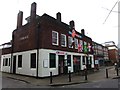
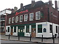
1
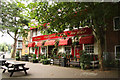
The Ship York
Free house pub on the corner of Rotherhithe Street and Elgar Street. This pub finally closed on 23 November 2014.
Image: © Richard Croft
Taken: 16 Aug 2011
0.01 miles
2
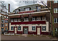
The Ship York
The Ship York public house. For a picture of the pub seen in happier days: Image
Image: © Peter McDermott
Taken: 6 Dec 2015
0.02 miles
3
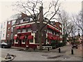
The Ship York, Rotherhithe
This pub finally closed on 23 November 2014.
Image: © Chris Whippet
Taken: 9 Feb 2014
0.02 miles
4
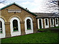
Trinity Church School - Rotherhithe Street, SE16
Situated at the junction with Bryan Road, built in 1836 being arranged by the Rev Edward Blick - rector of St Mary's from 1835 until his death on 25-06-1867. The school closed in 1910 with the opening of Redriff Road school some 500 yards east in Rotherhithe Street. One wall bears the mark of the 1928 flood and is 3'-2" from ground level. Main floods of the area were in 1881, 1904, 1928 and 1953 - the 'main' meaning that boats had to be used to get essentials to marooned families. Currently contains a toddlers' group and a security firm. See second image http://www.geograph.org.uk/photo/1483023
Image: © Chris Lordan
Taken: 21 Jun 2005
0.03 miles
5
Trinity Church School - Rotherhithe Street, SE16
See other image http://www.geograph.org.uk/photo/1483013 for complete description.
Image: © Chris Lordan
Taken: 9 Sep 2009
0.03 miles
6
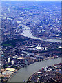
Greenland Dock from the air
Looking up the Thames from a Heathrow bound flight from Glasgow.
Image: © Thomas Nugent
Taken: 29 Aug 2011
0.03 miles
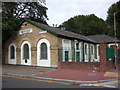
8
Surrey Commercial Dock Tavern pub - Rotherhithe Street, SE16
Seems a shame how this historic pub has been depicted. Opened about 1865 as the name of the title and was then at the junction with Derrick Street. Its postal address has varied from 351 Rotherhithe Street (1918) to 1 Redriff Road (1960) and then in 1970 back to its original address. Between 1920-28 it was known worldwide, via foreign seamen, as the "Fitchetts" after Mr Fitchett the licensee. For many years a lamp in the shape of a barrel bearing the name Fitchett hung outside the front. This disappeared in the late 1970s. It is believed the pub was built on the site of the 'Union Jack Beer House' 1832 - possibly 1865. As may be seen, it's now the 'Aardvark'
Image: © Chris Lordan
Taken: 9 Sep 2009
0.03 miles
9
Prince of Prussia pub (site of) Derrick Street, Rotherhithe, London, SE16
This stood from 1860 to 1874 ending as a restaurant - not a cafe, as many other Rotherhithe pubs did. In the late 1930's the Redriff Estate was built over Derrick Street and in particular the building shown. This, since the 1980's has been called Walker House. See image 'Redriff Estate' http://www.geograph.org.uk/photo/1509041 that will explain the large open area.
Image: © Chris Lordan
Taken: 9 Dec 2009
0.05 miles