IMAGES TAKEN NEAR TO
Brunswick Quay, LONDON, SE16 7PZ
Introduction
This page details the photographs taken nearby to Brunswick Quay, SE16 7PZ by members of the Geograph project.
The Geograph project started in 2005 with the aim of publishing, organising and preserving representative images for every square kilometre of Great Britain, Ireland and the Isle of Man.

There are currently over 7.5m images from over14,400 individuals and you can help contribute to the project by visiting https://www.geograph.org.uk
Image Map
Images are licensed for reuse under creativecommons.org/licenses/by-sa/2.0
Notes
- Clicking on the map will re-center to the selected point.
- The higher the marker number, the further away the image location is from the centre of the postcode.
Image Listing (224 Images Found)
Images are licensed for reuse under creativecommons.org/licenses/by-sa/2.0
Image
Details
Distance
2
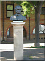
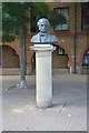
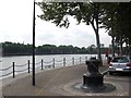
James Walker, Engineer
A bust on a stone pillar by the edge of Greenland Dock commemorates a former President of the Institution of Civil Engineers. His local connection was that he worked on building the Surrey Commercial Docks, remaining as engineer to the Surrey Commercial Dock Company until his death in 1862.
Image: © Stephen Craven
Taken: 22 May 2010
0.03 miles
5
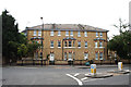
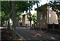
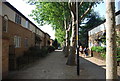
Rotherhithe: 1 and 3, Brunswick House
On Redriff Road.
Image: © Dr Neil Clifton
Taken: 15 Jun 2012
0.03 miles
6
Sir William Gomm public house (site of)
Site of that was in Commercial Street, Rotherhithe, SE16 (long demolished) from 1857 to 1873.Named after Sir William Maynard Gomm (1784-1875) Lord of the manor of Rotherhithe from 1822 until his death. Claimed that it was close to the dock and bought by the dock authorities when it was decided to lengthen Greenland Dock. Only one 'reasonable' place for its location on an 1868 map and by superimposing that map with a 1916 map (same scale) = position shown. Yellow lines indicate the path of Commercial Street. 50 yards behind me is the 'Moby Dick' pub. A second Sir W.G. pub was built in 1832 in Abbeyfield Road, SE16.
Image: © Chris Lordan
Taken: 19 Aug 2011
0.04 miles
10
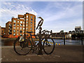
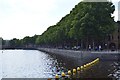
Memorial to Barry Mason
This sculpture on the edge of Greenland Dock is in the shape of a bicycle with a cormorant perched on it. It was unveiled on 16 August 2013, and is a tribute to Barry Mason (1950-2011) who was for many years a campaigner for cycling issues in Southwark borough, as well as having worked for the local council.
Image: © Stephen Craven
Taken: 21 Aug 2013
0.04 miles