IMAGES TAKEN NEAR TO
Albion Street, LONDON, SE16 7JU
Introduction
This page details the photographs taken nearby to Albion Street, SE16 7JU by members of the Geograph project.
The Geograph project started in 2005 with the aim of publishing, organising and preserving representative images for every square kilometre of Great Britain, Ireland and the Isle of Man.

There are currently over 7.5m images from over14,400 individuals and you can help contribute to the project by visiting https://www.geograph.org.uk
Image Map
Images are licensed for reuse under creativecommons.org/licenses/by-sa/2.0
Notes
- Clicking on the map will re-center to the selected point.
- The higher the marker number, the further away the image location is from the centre of the postcode.
Image Listing (629 Images Found)
Images are licensed for reuse under creativecommons.org/licenses/by-sa/2.0
Image
Details
Distance
1
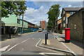
Northeast on Albion Street, Rotherhithe
The Overground station is a few steps to the northeast via Old Railway Walk, signposted left of centre. The postbox ID is SE16 10. The block of flats ahead is Pine House, one of several blocks named after trees. What would developers and councils do without trees to name so many blocks after?
Photo number 7784225.
Image: © Robin Stott
Taken: 27 May 2024
0.01 miles
2
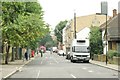
View along Albion Street
Looking south-southwest.
Image: © Robert Lamb
Taken: 12 Jul 2014
0.02 miles
3
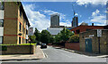
Clack Street, Rotherhithe
Stumbling across Clack Street recalled the end of 'Captain Carpenter', John Crowe Ransom's gruesome Crusader tale:
"The curses of hell upon the sleek upstart
That got the Captain finally on his back
And took the red, red vitals of his heart
And made the kites to whet their beaks clack clack."
Photo number 7784185.
Image: © Robin Stott
Taken: 27 May 2024
0.02 miles
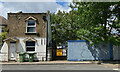
4
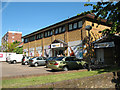
NISA local, Rotherhithe
Signs on this convenience store suggest it was newly opened in 2010. Presumably it competes for trade with nearby Londis Image It lies between Brunel Road (this side) and Albion Street; the Rotherhithe Road Tunnel runs under the car park.
Image: © Stephen Craven
Taken: 22 May 2010
0.02 miles
6
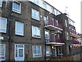
Albion Estate (part), Swan Road, Rotherhithe, London, SE16
Believed so named as it was only a matter of a few yards from Albion Yard and Albion Dock of the Surrey Commercial Docks. Consists of six blocks attached in a zig zag line and one separate 'L' shaped block.
Image: © Chris Lordan
Taken: 12 Oct 2009
0.03 miles
7
The southern entrance to Rotherhithe Tunnel
Image: © Mike Quinn
Taken: 9 Nov 2011
0.03 miles
8
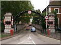
Gate to the tunnel, Rotherhithe
The tunnel referred to as closed on the yellow sign in Albion Street is the Rotherhithe road tunnel. The road descends to the tunnel mouth between white-tiled retaining walls. On each side is a long flight of steps down to footways, reached through elegant wrought-iron gates. That on the opposite (west) side is open: see Image and Image
Photo number 7784270.
Image: © Robin Stott
Taken: 27 May 2024
0.03 miles
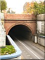
9
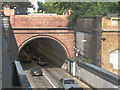
Rotherhithe road tunnel: southern portal
The tunnel is a single carriageway, i.e. two-way traffic. As an A-road rather than a motorway cycling is permitted but most cyclists consider it too dangerous as there is no room for cars to pass safely.
The inscription above the portal, which is grade 2 listed (LBS number 471268), reads: "This tunnel constructed by the London County Council was opened by HRH the Prince of Wales KG on the 12th of June 1908. Maurice Fitzmaurice CMG, Engineer"
NB the photo was digitally adjusted to make the tunnel interior more visible.
Image: © Stephen Craven
Taken: 22 May 2010
0.03 miles
10
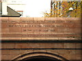
Inscription on the southern entrance to Rotherhithe Tunnel
See Image
Image: © Mike Quinn
Taken: 9 Nov 2011
0.03 miles