IMAGES TAKEN NEAR TO
Odessa Street, LONDON, SE16 7HD
Introduction
This page details the photographs taken nearby to Odessa Street, SE16 7HD by members of the Geograph project.
The Geograph project started in 2005 with the aim of publishing, organising and preserving representative images for every square kilometre of Great Britain, Ireland and the Isle of Man.

There are currently over 7.5m images from over14,400 individuals and you can help contribute to the project by visiting https://www.geograph.org.uk
Image Map
Images are licensed for reuse under creativecommons.org/licenses/by-sa/2.0
Notes
- Clicking on the map will re-center to the selected point.
- The higher the marker number, the further away the image location is from the centre of the postcode.
Image Listing (365 Images Found)
Images are licensed for reuse under creativecommons.org/licenses/by-sa/2.0
Image
Details
Distance
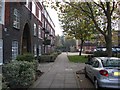
1
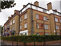
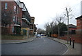
Redriff Estate (part), Rotherhithe, London, SE16
There are eight other blocks of varying sizes that complete the estate that is bounded by Rotherhithe Street, Elgar Street (Late York Street), Gulliver Street and Odessa Street (late Thames Street). Before the estate was built there was a Derrick Street (late Russel Street) between Elgar and Odessa Streets (about right of the image). Russel Street was named for the connection with the Duke of Bedfords family. Estate built 1931/40 as a community estate and comprised of a hall, gym, kitchen and hobby room with external facilities for football and cricket. Dignitaries from all over the UK attended the opening.
Image: © Chris Lordan
Taken: 23 Sep 2009
0.01 miles
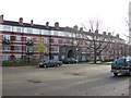
2
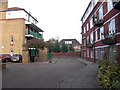
Lifeboat pub (site of), 6 Derrick Street, Rotherhithe, London SE16
The building on the right, Walker House of the Redriff Estate, was built over Derrick Street, previously Russell Street (Duke of Bedford connection). There were two pubs in the street; this one was first recorded in 1863 and closed in 1890. The other side of the facing brick wall is the Surrey Commercial Dock Tavern (now Aardvark); see Image
Image: © Chris Lordan
Taken: 11 Nov 2009
0.01 miles
5
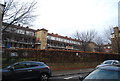
Greyhound pub (site of) 47 Russell Street, Rotherhithe, London SE16
The building on the left, Walker House of the Redriff Estate, was built over Russell Street, named in connection with the Duke of Bedford. The name was later changed to Derrick Street. There were two pubs in the street; this one was first recorded in 1862 and closed in 1894. It was previously the 'Vulcan Beer House'. At the end of the building shown and across Gulliver Street is the Ship & Whale pub; see Image
Image: © Chris Lordan
Taken: 11 Nov 2009
0.02 miles
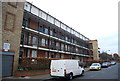
6
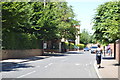
Prince of Prussia pub (site of) Derrick Street, Rotherhithe, London, SE16
This stood from 1860 to 1874 ending as a restaurant - not a cafe, as many other Rotherhithe pubs did. In the late 1930's the Redriff Estate was built over Derrick Street and in particular the building shown. This, since the 1980's has been called Walker House. See image 'Redriff Estate' http://www.geograph.org.uk/photo/1509041 that will explain the large open area.
Image: © Chris Lordan
Taken: 9 Dec 2009
0.02 miles
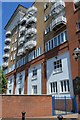
10
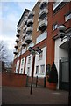
New Caledonian Wharf
A luxury riverside apartment block.
Image: © N Chadwick
Taken: 17 Feb 2012
0.04 miles