IMAGES TAKEN NEAR TO
Rope Street, LONDON, SE16 7EX
Introduction
This page details the photographs taken nearby to Rope Street, SE16 7EX by members of the Geograph project.
The Geograph project started in 2005 with the aim of publishing, organising and preserving representative images for every square kilometre of Great Britain, Ireland and the Isle of Man.

There are currently over 7.5m images from over14,400 individuals and you can help contribute to the project by visiting https://www.geograph.org.uk
Image Map
Images are licensed for reuse under creativecommons.org/licenses/by-sa/2.0
Notes
- Clicking on the map will re-center to the selected point.
- The higher the marker number, the further away the image location is from the centre of the postcode.
Image Listing (261 Images Found)
Images are licensed for reuse under creativecommons.org/licenses/by-sa/2.0
Image
Details
Distance
2
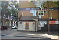
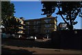
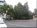
Plough public house (1) (site of)
Site of that was in Commercial Dock Road (long demolished), Rotherhithe, SE16 opposite Plough Road (now Plough Way). Opened 1746 and closed 1900 when the land was taken over by the dock authorities to expand the dock area. Pub moved to Plough Road - see Image Site now occupied by the dwellings shown which are in Rope Street at the junction with Sweden Gate.
Image: © Chris Lordan
Taken: 17 Aug 2011
0.01 miles
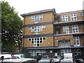
6
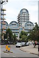
Baltic Quay
Large apartment blocks.
Image: © Oast House Archive
Taken: 26 Jun 2014
0.03 miles
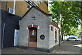
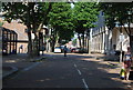
8
Rising Sun public house (site of)
Site of that was in Commercial Dock Road (long demolished),Rotherhithe,SE16 close to London Road (long demolished), Deptford,SE8. Pub only lasted from 1851 to 1867. Behind the trees in the image stands the converted Surrey Commercial Dock police station. Both roads mentioned formed part of Plough Way and the road to the left of the image is Sweden Gate off the re-routed Plough Way.
Image: © Chris Lordan
Taken: 17 Aug 2011
0.04 miles
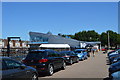
9
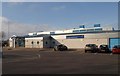
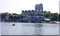
Surrey Docks Watersports Centre
The rear of the centre seen across the car park; Greenland Dock is on the other side. The centre opened in its present form in February 2010, almost a exactly year before this photo was taken.
Image: © Derek Harper
Taken: 9 Feb 2011
0.04 miles