IMAGES TAKEN NEAR TO
Ainsty Estate, LONDON, SE16 7DQ
Introduction
This page details the photographs taken nearby to Ainsty Estate, SE16 7DQ by members of the Geograph project.
The Geograph project started in 2005 with the aim of publishing, organising and preserving representative images for every square kilometre of Great Britain, Ireland and the Isle of Man.

There are currently over 7.5m images from over14,400 individuals and you can help contribute to the project by visiting https://www.geograph.org.uk
Image Map
Images are licensed for reuse under creativecommons.org/licenses/by-sa/2.0
Notes
- Clicking on the map will re-center to the selected point.
- The higher the marker number, the further away the image location is from the centre of the postcode.
Image Listing (627 Images Found)
Images are licensed for reuse under creativecommons.org/licenses/by-sa/2.0
Image
Details
Distance
1
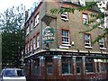
The Lord Nelson, SE16
On the corner of Canon Beck Road & Albion Road.
Not sure what was going to happen to this pub, there were workmen inside the building, but I didn't enquire if it was to remain as a pub or not.
Image: © Phillip Perry
Taken: 21 Sep 2009
0.01 miles
2
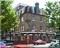
The Lord Nelson, Albion Street
Not sure at the time the pub was actually open, but in any case at the time of writing (2016) it does appear to have closed and been turned into an art gallery. Glazed brick ground floor and adverts for Watney Combe Reid (1898), Watney's ales, Reid's stout and Combe's brown ale survive(d). Above the main sign is some corbelling.
Image: © Stephen Richards
Taken: 26 May 2013
0.03 miles
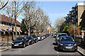
3
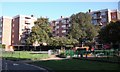
Ainsty Estate (part), Rotherhithe, London SE16
The estate consists of three blocks: Beech House (shown) in Canon Beck Road, Larch House in Swan Road and Pine House in Albion Street. Built in 1953 over Ainsty Street of which only about 15 yards remains. See image of Image re definition.
Image: © Chris Lordan
Taken: 12 Oct 2009
0.03 miles
6
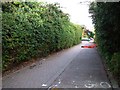
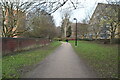
Swan Road
A quiet urban street in Rotherhithe - even more than usual on the morning of the London Marathon.
Image: © Martin Addison
Taken: 22 Apr 2012
0.05 miles
7
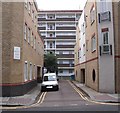
Ainsty Street, Rotherhithe, London, SE16
Off Brunel Road and about 75 yards west of Canon Beck Road and originally called York Street, stretching from the boundary fence of Surrey Docks to about 100 yards north of Brunel Road. At the bottom is the rear of Pine House to the right of which (out of view) can be found Larch House - to the left (again out of view) can be found Beech House. All three form the Ainsty Estate. "Ainsty" is an old name for an area close to the City of York.
Image: © Chris Lordan
Taken: 23 Sep 2009
0.06 miles
9
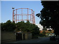
Gasometer, Rotherhithe
An example of adapting old structures to new uses - a disused gasometer now hosts mobile phone masts.
Image: © Stephen Craven
Taken: 4 Jul 2006
0.06 miles
10
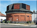
Air shaft, Brunel Road
Above Rotherhithe Tunnel. A plaque records that it was "constructed between 1904 and 1908 by the engineer Sir Maurice Fitzmaurice".
Image: © Stephen Richards
Taken: 26 May 2013
0.07 miles