IMAGES TAKEN NEAR TO
Lovell Place, LONDON, SE16 6QQ
Introduction
This page details the photographs taken nearby to Lovell Place, SE16 6QQ by members of the Geograph project.
The Geograph project started in 2005 with the aim of publishing, organising and preserving representative images for every square kilometre of Great Britain, Ireland and the Isle of Man.

There are currently over 7.5m images from over14,400 individuals and you can help contribute to the project by visiting https://www.geograph.org.uk
Image Map
Images are licensed for reuse under creativecommons.org/licenses/by-sa/2.0
Notes
- Clicking on the map will re-center to the selected point.
- The higher the marker number, the further away the image location is from the centre of the postcode.
Image Listing (325 Images Found)
Images are licensed for reuse under creativecommons.org/licenses/by-sa/2.0
Image
Details
Distance
4
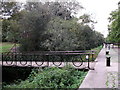
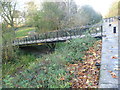
Alfred Salter footbridge, Russia Dock Woodlands
This bridge leads from the Stave Hill/Redriff Road footpath (Waterman's Walk) through the woodland of Russia Dock Woodlands.
It passes over a small woodland stream, all that remains of Russia Dock. Which was filled in to create the woodland area.
The bridge is named after a British medical practitioner and Labour Party politician of the early 1940's . See http://en.wikipedia.org/wiki/Alfred_Salter for more details on the man and his work.
Image: © David Anstiss
Taken: 25 Sep 2011
0.08 miles
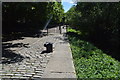
5
Bridge next to the old dockside at Russia Dock Woodland
Russia Dock was part of the Surrey Commercial Docks and was originally used for the importing of timber from Norway, Russia and Sweden. The soft wood was mostly used for paper for prints and for furniture. Following the closure of the Surrey Commercial Docks in the 1970s, Russia Dock was in filled in 1980, apart from a thin 'stream', and planted as a woodland in the same year. A series of water channels and ponds provided habitats for kingfishers and herons. It still contains surviving dock features including the retaining wall, capstones, depth gauges, bollards, mooring chains and tracks. The bridges, one of which is seen here, have been added.
Image: © Marathon
Taken: 9 Nov 2011
0.08 miles
6
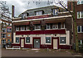
The Ship York
The Ship York public house. For a picture of the pub seen in happier days: Image
Image: © Peter McDermott
Taken: 6 Dec 2015
0.08 miles
7
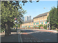
Bus stop on Redriff Road, Rotherhithe
The name of the road apparently represents a (former) local pronunciation of the place-name (Roth'riff -> Redriff?)
The bus stop in the foreground is served by routes 381 and C10.
Image: © Stephen Craven
Taken: 22 May 2010
0.08 miles
8
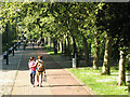
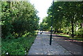
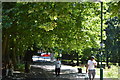
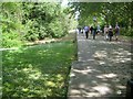
Waterman's Walk
A lovely warm day in May and a couple set off along the 400m long tree-lined path towards Russia Docks Woodland.
Image: © Stephen Craven
Taken: 22 May 2010
0.08 miles
9
Rotherhithe: Former Russia Dock
This is the stone quayside on the eastern side of the former Russia Dock. Some idea of the size of the original dock can gleaned from the fact that this quayside continues in a straight line from here for nearly 700 metres. The dock was to the left but has since been filled in, landscaped and vegetated as the Russia Dock Woodland.
Image: © Nigel Cox
Taken: 24 May 2019
0.08 miles
10
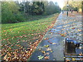
The old dockside at Russia Dock Woodland
Russia Dock was part of the Surrey Commercial Docks and was originally used for the importing of timber from Norway, Russia and Sweden. The soft wood was mostly used for paper for prints and for furniture. Following the closure of the Surrey Commercial Docks in the 1970s, Russia Dock was in filled in 1980, apart from a thin 'stream', and planted as a woodland in the same year. A series of water channels and ponds provided habitats for kingfishers and herons. It still contains surviving dock features including the retaining wall, capstones, depth gauges, bollards, mooring chains and tracks.
Image: © Marathon
Taken: 9 Nov 2011
0.08 miles