IMAGES TAKEN NEAR TO
Howland Way, LONDON, SE16 6HN
Introduction
This page details the photographs taken nearby to Howland Way, SE16 6HN by members of the Geograph project.
The Geograph project started in 2005 with the aim of publishing, organising and preserving representative images for every square kilometre of Great Britain, Ireland and the Isle of Man.

There are currently over 7.5m images from over14,400 individuals and you can help contribute to the project by visiting https://www.geograph.org.uk
Image Map
Images are licensed for reuse under creativecommons.org/licenses/by-sa/2.0
Notes
- Clicking on the map will re-center to the selected point.
- The higher the marker number, the further away the image location is from the centre of the postcode.
Image Listing (274 Images Found)
Images are licensed for reuse under creativecommons.org/licenses/by-sa/2.0
Image
Details
Distance
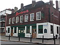
1
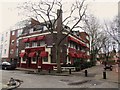
The Ship York, Rotherhithe
This pub finally closed on 23 November 2014.
Image: © Chris Whippet
Taken: 9 Feb 2014
0.06 miles
2
Acorn Public House - site of
It was at 339 Rotherhithe Street, Rotherhithe, London SE16 from 1787 until 1942, when, I assume, it was destroyed by enemy bombing. Today's street numbers are 325-327.
Image: © Chris Lordan
Taken: 20 Feb 2011
0.06 miles
3
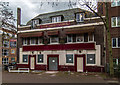
The Ship York
The Ship York public house. For a picture of the pub seen in happier days: Image
Image: © Peter McDermott
Taken: 6 Dec 2015
0.06 miles
4
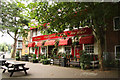
The Ship York
Free house pub on the corner of Rotherhithe Street and Elgar Street. This pub finally closed on 23 November 2014.
Image: © Richard Croft
Taken: 16 Aug 2011
0.07 miles
5
Holy Trinity, Rotherhithe Street, Rotherhithe - - War Memorial
Image: © John Salmon
Taken: 17 Feb 2011
0.09 miles
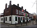
6
Surrey Commercial Dock Tavern pub - Rotherhithe Street, SE16
Seems a shame how this historic pub has been depicted. Opened about 1865 as the name of the title and was then at the junction with Derrick Street. Its postal address has varied from 351 Rotherhithe Street (1918) to 1 Redriff Road (1960) and then in 1970 back to its original address. Between 1920-28 it was known worldwide, via foreign seamen, as the "Fitchetts" after Mr Fitchett the licensee. For many years a lamp in the shape of a barrel bearing the name Fitchett hung outside the front. This disappeared in the late 1970s. It is believed the pub was built on the site of the 'Union Jack Beer House' 1832 - possibly 1865. As may be seen, it's now the 'Aardvark'
Image: © Chris Lordan
Taken: 9 Sep 2009
0.09 miles
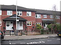
7
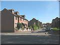
Somerford Way, Rotherhithe
A street of modern housing off Downtown Road.
Image: © Stephen Craven
Taken: 22 May 2010
0.09 miles
9
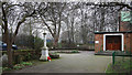
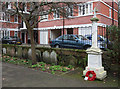
Holy Trinity, Rotherhithe Street, Rotherhithe - Churchyard
With War Memorial
Image: © John Salmon
Taken: 17 Feb 2011
0.09 miles
10
Salter Road at the junction of Downtown Road
Image: © David Howard
Taken: 12 Aug 2017
0.09 miles