IMAGES TAKEN NEAR TO
Rotherhithe Street, LONDON, SE16 5EY
Introduction
This page details the photographs taken nearby to Rotherhithe Street, SE16 5EY by members of the Geograph project.
The Geograph project started in 2005 with the aim of publishing, organising and preserving representative images for every square kilometre of Great Britain, Ireland and the Isle of Man.

There are currently over 7.5m images from over14,400 individuals and you can help contribute to the project by visiting https://www.geograph.org.uk
Image Map
Images are licensed for reuse under creativecommons.org/licenses/by-sa/2.0
Notes
- Clicking on the map will re-center to the selected point.
- The higher the marker number, the further away the image location is from the centre of the postcode.
Image Listing (315 Images Found)
Images are licensed for reuse under creativecommons.org/licenses/by-sa/2.0
Image
Details
Distance
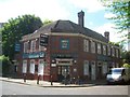
1
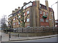
Wheatsheaf pub (site of) 344, Rotherhithe Street, London SE16
First recorded in 1805, it stopped trading as a pub in 1909 although it continued as a café for a short period of time. It had to compete for customers against the 'Three Compasses' to its immediate left on the junction with Beatson Street, and the 'Globe' immediately opposite it. Image shows part of Lavender House behind which is Peter Hills with St Mary's and St Paul's Church of England School.
Image: © Chris Lordan
Taken: 24 Nov 2009
0.01 miles
2
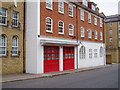
Pageants Wharf Fire Station, Rotherhithe Street, London SE16
Opened 05-03-1903 at a cost of £3280 and closed in 1969 with the demise of Surrey Commercial Docks. The unusual feature about the units based at the station was that they were not allowed to cross over the bascule bridges either end of Rotherhithe Street and Redriff Road. This was to ensure that if a fire broke out between the bridges at least some assistance would be guaranteed. After it closed the building was taken over by the Brooks Brothers as a car body repair shop. This did so well that they later became a main Ford agent with new premises in Bermondsey.
Image: © Chris Lordan
Taken: 7 Aug 2005
0.01 miles
3
Queens Head Ale House
This stood from 1743 until 1787 about 50 yards from today's 'Clipper' (centre of image). It was later named 'The George' and 'George Gin Shop'. The location is approximate :- the original 'Clipper' (when Ship) was 50 yards further east (right), so if it was 50 yards east of the original location it would make it where the bushes are : if 50 yards east of the present, it would make it at the left of the image. Main building shown is 'Timbrell Place'. http://www.geograph.org.uk/photo/1546265
Image: © Chris Lordan
Taken: 11 Dec 2009
0.02 miles
4
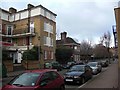
Queens Head pub (site of) 243, Rotherhithe Street, London, SE16
First recorded about 1805 and demolished in 1928. It would have stood where the larger of the two walls can be seen and abutting, on its right, to 'Enthovens' a large lead and solder manufacturer. This company bought the pub in 1927 to extend their premises. White building on the left is the Pageants Wharf fire station (1903 - 1969).
Image: © Chris Lordan
Taken: 24 Nov 2009
0.02 miles
5
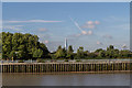
South Bank of The Thames, Rotherhithe
With the curve of the river we can now see the Shard and No. 20 Fenchurch Street.
Image: © Christine Matthews
Taken: 12 Oct 2013
0.03 miles
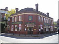
6
Rotherhithe: The Clipper
Or He Clippe as its nameboard now states.
Please compare with Peter's Image] from 2015, which shows the building in much the same state. However there is now a Sold sign on it.
Old large scale Ordnance Survey maps show that the pub was once named the "Ship".
Image: © Nigel Cox
Taken: 24 May 2019
0.03 miles
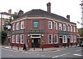
7
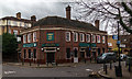
The Clipper
The Clipper public house.
Image: © Peter McDermott
Taken: 6 Dec 2015
0.03 miles
8
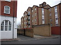
White Horse pub (site of) Rotherhithe Street, London, SE16
This was on the riverside of the street practically opposite Cow Lane and at the north end of Durands Wharf. Commenced trading in 1743 and demolished in 1962 although I do not know when it ceased trading. Cow Lane was on the land side and about 120 yards south of today's 'Clipper' pub. Site shown is a riverside walk named Durands Wharf'. I do not know what the concrete structure is but from the noise coming from it, it could be some type of ventilation shaft.It is in fact the ventilation shaft for the Jubilee Line (I should have realised) [Thanks Stephen Craven]
Image: © Chris Lordan
Taken: 1 Dec 2009
0.03 miles
9
The Ship pub (ex) 538, Rotherhithe Street, London, SE16
At the junction with Silver Walk and first recorded in 1805 but on a site a little to the west (right) - present building dates from 1934. Pub now called "The Clipper" - has in the past been called "Mermaids Galley Alehouse", "Ship York" and "Ship Tavern". Now missing the three doors that are covered by advertising boards / menus and the sign 'Open all day' was where a good image of a sailing ship was built into the brickwork.
Image: © Chris Lordan
Taken: 19 Oct 2009
0.04 miles
10
The Clipper Pub, Rotherhithe
Rotherhithe Street, Rotherhithe LONDON SE16 5EX close to The River Thames Tideway
Image: © canalandriversidepubs co uk
Taken: 23 Apr 2010
0.04 miles