IMAGES TAKEN NEAR TO
Cherry Garden Street, LONDON, SE16 4PE
Introduction
This page details the photographs taken nearby to Cherry Garden Street, SE16 4PE by members of the Geograph project.
The Geograph project started in 2005 with the aim of publishing, organising and preserving representative images for every square kilometre of Great Britain, Ireland and the Isle of Man.

There are currently over 7.5m images from over14,400 individuals and you can help contribute to the project by visiting https://www.geograph.org.uk
Image Map
Images are licensed for reuse under creativecommons.org/licenses/by-sa/2.0
Notes
- Clicking on the map will re-center to the selected point.
- The higher the marker number, the further away the image location is from the centre of the postcode.
Image Listing (396 Images Found)
Images are licensed for reuse under creativecommons.org/licenses/by-sa/2.0
Image
Details
Distance
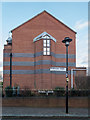
1
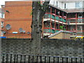
Cherry Gardens Street
Maintaining its name,Cherry Gardens Street,and its location on the south bank of the River Thames, the new look hides the long history of this place and its many visitors (including Samuel Pepys.)
Image: © John Tustin
Taken: 1 Aug 2010
0.03 miles
2
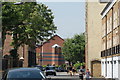
View down Cherry Garden Street from Bermondsey Wall East
Looking south-southeast.
Image: © Robert Lamb
Taken: 12 Jul 2014
0.03 miles
3
Morriss House, Marigold Street, London SE16
It is spelt that way Image]
Image: © Christine Matthews
Taken: 8 Mar 2015
0.04 miles
4
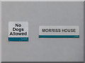
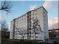
Name Plaque on Morriss House, Marigold Street, London SE16
Here is a view of the whole apartment block Image]
Image: © Christine Matthews
Taken: 8 Mar 2015
0.04 miles
6
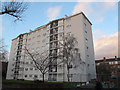
Morriss House, Marigold Street, Bermondsey
Morriss House (the spelling with double s is not a mistake) is an 8 storey tower block constructed in the late 1950s as part of the Cherry Garden estate. Source: http://ukhousing.wikia.com/wiki/Morriss_House
Image: © Stephen Craven
Taken: 8 Mar 2015
0.04 miles
7
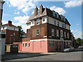
The old Two Brewers
This building is now residential but was formerly the Two brewers pub.
Image: © Stephen Craven
Taken: 21 May 2011
0.04 miles
8
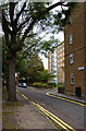
Marigold Street
One of several narrow sidestreets running through the estate beside Cherry Garden Pier.
Image: © Martin Addison
Taken: 22 Oct 2010
0.04 miles
9
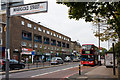
A200, Jamaica Road
A view of this busy dual carriageway from the junction with Marigold Street close to the, somewhat indistinct, boundary between Bermondsey and Rotherhithe. A Canada Water bound 47 bus, an Alexander bodied Dennis Trident, pauses to collect passengers at the Drummond Road stop. Opposite is a parade of shops with flats above constructed after World War II - much of the area having suffered bombing during the London Blitz.
Image: © Martin Addison
Taken: 22 Oct 2010
0.04 miles
10
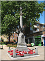
West Lane war memorial
A memorial to two groups: the men of the area who died fighting in the two world wars, and the firefighters who died in the course of duty in the heavy bombing of the Second World War. It is situated in a small garden on the east side of West Lane. Listed grade 2 (List Entry Number 1393872).
For other views, see Image and Image
Image: © Stephen Craven
Taken: 21 May 2011
0.05 miles