IMAGES TAKEN NEAR TO
King Stairs Close, LONDON, SE16 4JF
Introduction
This page details the photographs taken nearby to King Stairs Close, SE16 4JF by members of the Geograph project.
The Geograph project started in 2005 with the aim of publishing, organising and preserving representative images for every square kilometre of Great Britain, Ireland and the Isle of Man.

There are currently over 7.5m images from over14,400 individuals and you can help contribute to the project by visiting https://www.geograph.org.uk
Image Map
Images are licensed for reuse under creativecommons.org/licenses/by-sa/2.0
Notes
- Clicking on the map will re-center to the selected point.
- The higher the marker number, the further away the image location is from the centre of the postcode.
Image Listing (818 Images Found)
Images are licensed for reuse under creativecommons.org/licenses/by-sa/2.0
Image
Details
Distance
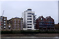
3
New ramp under Kings Stairs Close
The first floor of the apartment block at Kings Stairs Close projects over the Thames Path, which at this point is also part of National Cycle Route 4. For several years after this designation cyclists would have to walk their bikes up or down a short flight of stairs here, but a ramp was installed c.2009 to make things easier.
Image: © Stephen Craven
Taken: 22 May 2010
0.02 miles
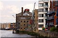
4
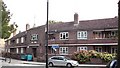
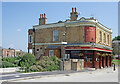
White Lion pub (site of) 85, Rotherhithe Street, London, SE16
This stood alongside Prince's Stairs from 1805 until 1931 and opposite Prince's Street - now Mayflower Street. From 1843 to 1883 it was in the hands of the Garth family. Site now occupied by houses shown, with an address of King Stairs Close, behind which is a riverside walkway.
Image: © Chris Lordan
Taken: 4 Nov 2009
0.02 miles
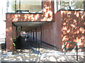
5
Henley Close, St Marychurch Street, Rotherhithe, London, SE16
Viewed from St Marys Estate. Named after Councillor Albert Henley, ex mayor of Bermondsey, who was killed on 11-05-1941 fighting incendiary bombs that had fallen on the roof of the Bermondsey Town Hall in Spa Road, London, SE1.
Image: © Chris Lordan
Taken: 23 Sep 2009
0.03 miles
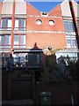
6
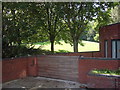
Bunch of Grapes public house - site of
This was at 94 Rotherhithe Street, London, SE16 from 1821 to 1888. It would have stood about where the right hand tree now stands. Building shown is the last building at the west end of Kings Stairs Close.
Image: © Chris Lordan
Taken: 2 Sep 2011
0.03 miles
7
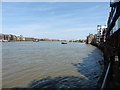
View of the disused pier in Rotherhithe from the Thames Path
Looking east.
Image: © Robert Lamb
Taken: 12 Jul 2014
0.03 miles
8
View of the disused pier in Rotherhithe from the Thames Path #2
Looking east.
Image: © Robert Lamb
Taken: 12 Jul 2014
0.03 miles
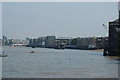
9
The Thames Path National Trail near Rotherhithe Station
Image: © Dave Kelly
Taken: 18 May 2018
0.03 miles
10
Rotherhithe : "The Angel" public house
Grade II listed : description at this https://historicengland.org.uk/listing/the-list/list-entry/1376583.
Image: © Jim Osley
Taken: 19 Jul 2021
0.03 miles