IMAGES TAKEN NEAR TO
St. James's Road, LONDON, SE16 4ET
Introduction
This page details the photographs taken nearby to St. James's Road, SE16 4ET by members of the Geograph project.
The Geograph project started in 2005 with the aim of publishing, organising and preserving representative images for every square kilometre of Great Britain, Ireland and the Isle of Man.

There are currently over 7.5m images from over14,400 individuals and you can help contribute to the project by visiting https://www.geograph.org.uk
Image Map
Images are licensed for reuse under creativecommons.org/licenses/by-sa/2.0
Notes
- Clicking on the map will re-center to the selected point.
- The higher the marker number, the further away the image location is from the centre of the postcode.
Image Listing (405 Images Found)
Images are licensed for reuse under creativecommons.org/licenses/by-sa/2.0
Image
Details
Distance
1
Shops on Jamaica Road
At the junction of Jamaica Road and Drummond Road
Image: © Robert Eva
Taken: 11 Jan 2020
0.02 miles
2
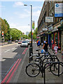
Jamaica Road, Bermondsey
Looking east along Jamaica Road, the A200, a main route into south-east London. The name is believed to have derived from Jamaica House which stood nearby until about 1860. The house is mentioned by Samuel Pepys in his diary in 1667, and was itself probably named after the newly-acquired colony.
Image: © Stephen McKay
Taken: 27 Jul 2007
0.02 miles
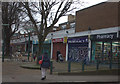
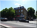
4
Shops on Jamaica Road, Bermondsey
Closed because it was after 5pm on Sunday.
Image: © Stephen Craven
Taken: 8 Mar 2015
0.03 miles
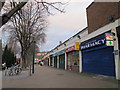
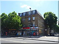
5
Post Office and shops on Jamaica Road
London SE16.
Image: © JThomas
Taken: 20 Jun 2022
0.04 miles
6
Jamaica Road Post Office
Showing position of postbox No. SE16 106.
See Image] for postbox.
Image: © JThomas
Taken: 20 Jun 2022
0.04 miles
7
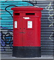
Double aperture Elizabeth II postbox on Jamaica Road
Postbox No. SE16 106.
See Image] for context.
Image: © JThomas
Taken: 20 Jun 2022
0.04 miles
8
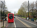
Bus at westbound Drummond Road stop
On the A200 Jamaica Road.
Image: © Robin Webster
Taken: 6 Apr 2019
0.05 miles
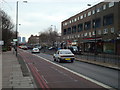
9
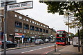
A200, Jamaica Road
A view of this busy dual carriageway from the junction with Marigold Street close to the, somewhat indistinct, boundary between Bermondsey and Rotherhithe. A Canada Water bound 47 bus, an Alexander bodied Dennis Trident, pauses to collect passengers at the Drummond Road stop. Opposite is a parade of shops with flats above constructed after World War II - much of the area having suffered bombing during the London Blitz.
Image: © Martin Addison
Taken: 22 Oct 2010
0.05 miles
10
Ornament in Garden, Bermondsey, London SE1
Image: © Christine Matthews
Taken: 8 Mar 2015
0.05 miles