IMAGES TAKEN NEAR TO
Freda Street, LONDON, SE16 4ED
Introduction
This page details the photographs taken nearby to Freda Street, SE16 4ED by members of the Geograph project.
The Geograph project started in 2005 with the aim of publishing, organising and preserving representative images for every square kilometre of Great Britain, Ireland and the Isle of Man.

There are currently over 7.5m images from over14,400 individuals and you can help contribute to the project by visiting https://www.geograph.org.uk
Image Map
Images are licensed for reuse under creativecommons.org/licenses/by-sa/2.0
Notes
- Clicking on the map will re-center to the selected point.
- The higher the marker number, the further away the image location is from the centre of the postcode.
Image Listing (363 Images Found)
Images are licensed for reuse under creativecommons.org/licenses/by-sa/2.0
Image
Details
Distance
1
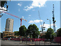
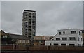
Bermondsey Spa development
Bermondsey Spa is a major redevelopment over several years of the area between Jamaica Road and Grange Road. Here, cranes are working on one of the later phases of development at the junction of Jamaica Road and Abbey Road.
Image: © Stephen Craven
Taken: 21 May 2011
0.01 miles
2
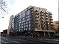
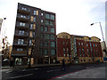
Bermondsey Spa: Apartment block with Tesco Metro
A recently completed apartment block on the corner of Abbey Street and Jamaica Road, with a supermarket occupying the ground floor.
Image: © Stephen Craven
Taken: 25 Jan 2014
0.02 miles
3
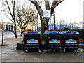
Recycling point on Jamaica Road
Three bins for mixed dry recycling.
Image: © Stephen Craven
Taken: 25 Jan 2014
0.03 miles
4
Bermondsey Spa: Abbey Street development
A recently completed apartment block.
Image: © Stephen Craven
Taken: 25 Jan 2014
0.03 miles
5
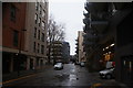
View down Marine Street from Jamaica Road
Looking south-southwest.
Image: © Robert Lamb
Taken: 27 Jan 2019
0.03 miles
6
Junction of Jamaica Road and Abbey Street, SE1
A200 straight on towards London Bridge, B202 left.
Image: © Robin Webster
Taken: 6 Apr 2019
0.04 miles
7
The eastern end of Abbey Street
Abbey Street generally runs west-east, but at this end turns north-east to meet Jamica Road as shown here. The view includes a telephone box and traffic lights.
Image: © Stephen Craven
Taken: 25 May 2012
0.04 miles
8
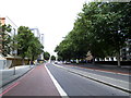
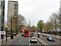
Jamaica Road, looking west
This, the main road from London Bridge to Rotherhithe, has been a dual carriageway since the 1970s. On this occasion access for traffic was restricted as part of the Ride London festival weekend.
Image: © Stephen Craven
Taken: 3 Aug 2013
0.04 miles
9
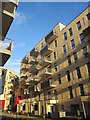
Kimmins Court
New block of apartments on Old Jamaica Road.
The building with the red panels is the Parker Building.
Image: © David Anstiss
Taken: 8 Mar 2015
0.04 miles