IMAGES TAKEN NEAR TO
Sun Passage, LONDON, SE16 4BP
Introduction
This page details the photographs taken nearby to Sun Passage, SE16 4BP by members of the Geograph project.
The Geograph project started in 2005 with the aim of publishing, organising and preserving representative images for every square kilometre of Great Britain, Ireland and the Isle of Man.

There are currently over 7.5m images from over14,400 individuals and you can help contribute to the project by visiting https://www.geograph.org.uk
Image Map (Loading...)


Getting Data...Please wait
Leaflet Map data © OpenStreetMap
Images are licensed for reuse under creativecommons.org/licenses/by-sa/2.0
Notes
- Clicking on the map will re-center to the selected point.
- The higher the marker number, the further away the image location is from the centre of the postcode.
Image Listing (308 Images Found)
Images are licensed for reuse under creativecommons.org/licenses/by-sa/2.0
Image
Details
Distance
1
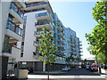
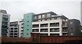
Old Jamaica Road, Bermondsey
Part of the Bermondsey Spa development, the curved building in this view includes a health centre.
Image: © Stephen Craven
Taken: 25 May 2012
0.02 miles
2
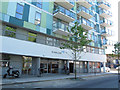
Spa Medical Centre, Bermondsey
For context, see Image
Image: © Stephen Craven
Taken: 25 May 2012
0.03 miles

4
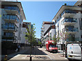
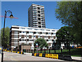
Frean Street, Bermondsey
A largely pedestrianised street, part of the Bermondsey Spa estate.
Image: © Stephen Craven
Taken: 25 May 2012
0.03 miles
5
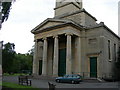
St James Church, Thurland Road, SE16 (1)
Showing the lower half of the building. For a picture of the spire, click here Image
Image: © Danny P Robinson
Taken: 15 Jun 2007
0.03 miles
6
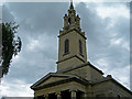
St James Church, Thurland Road, SE16 (2)
Showing the spire -- for a picture at ground level click here Image
Image: © Danny P Robinson
Taken: 15 Jun 2007
0.03 miles
9
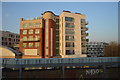
Marine Street, Bermondsey
Surrounded by the newere blocks of the Bermondsey Spa development, these are buildings from the previous generation: in the background Casby House, and nearer to the camera a low-rise building on Marine Street (foreground).
Image: © Stephen Craven
Taken: 25 May 2012
0.05 miles
10
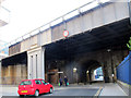
Marine Street railway bridge, Bermondsey: north end
This section of the former Rouel Road is now called Marine Street. One of several streets crossed by the original London and Greenwich railway viaduct (and its later widenings) - the total length (from the road users point of view) of this bridge is 50m, making it more of a road tunnel. The height restriction is 4.2 metres, but there are bollards restricting it in practice to cycle and pedestrian use. See Image for the opposite end.
Image: © Stephen Craven
Taken: 8 Mar 2015
0.05 miles