IMAGES TAKEN NEAR TO
Neckinger, LONDON, SE16 3QL
Introduction
This page details the photographs taken nearby to Neckinger, SE16 3QL by members of the Geograph project.
The Geograph project started in 2005 with the aim of publishing, organising and preserving representative images for every square kilometre of Great Britain, Ireland and the Isle of Man.

There are currently over 7.5m images from over14,400 individuals and you can help contribute to the project by visiting https://www.geograph.org.uk
Image Map
Images are licensed for reuse under creativecommons.org/licenses/by-sa/2.0
Notes
- Clicking on the map will re-center to the selected point.
- The higher the marker number, the further away the image location is from the centre of the postcode.
Image Listing (226 Images Found)
Images are licensed for reuse under creativecommons.org/licenses/by-sa/2.0
Image
Details
Distance
1
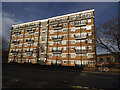
Neckinger, Bermondsey
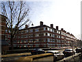
Neckinger. Not so much the name of a street as of the river that flows underground beneath Abbey Street at this end, as part of its 2.6 mile journey under South London. The Neckinger joins the Thames at St Saviour’s Dock. The watercourse provided a water supply for tanneries and factories. One of the largest leather factories in Bermondsey was Bevington’s Neckinger Mills on Abbey Street Image The housing shown here is typical of the old LCC (London County Council) estates.
Image: © Stephen Craven
Taken: 25 Jan 2014
0.02 miles
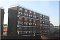

4
New Amelia House, Abbey Street, Bermondsey
This five-storey block occupying a wedge-shaped site next to the railway viaduct is on the site of a former petrol station. See also Image
Image: © Stephen Craven
Taken: 8 Mar 2015
0.04 miles
5
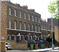
142-148 Abbey Street
Funny how odd clusters of older buildings survive comprehensive development that sweeps away so much else. These are early C19th. Grade II listed.
The two-storey buildings do not appear to be listed.
Image: © Stephen Richards
Taken: 27 May 2013
0.04 miles
6
Rufus House, Abbey Street, Bermondsey
One of several similar blocks in the area.
Image: © Stephen Craven
Taken: 25 Jan 2014
0.04 miles
7

Railway Arches, Enid Street, London SE1
Image: © Christine Matthews
Taken: 8 Mar 2015
0.04 miles
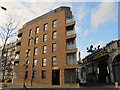
8
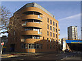
New housing on Gedling Place
This five-storey block, New Amelia House, occupying a wedge-shaped site next to the railway viaduct is on the site of a former petrol station. See also Image
Image: © Stephen Craven
Taken: 25 Jan 2014
0.05 miles
9
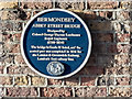
Blue Plaque on Abbey Street Bridge, London SE1
This bridge is Grade II listed - the central part was completed for in 1836 for the London and Greenwich Railway, London's first railway line.
Image: © Christine Matthews
Taken: 8 Mar 2015
0.05 miles
10

Abbey Street Railway Bridge, London SE1
This bridge is Grade II listed - the central part was completed for in 1836 for the London and Greenwich Railway, London's first railway line.
Image: © Christine Matthews
Taken: 8 Mar 2015
0.05 miles