IMAGES TAKEN NEAR TO
Rennie Estate, LONDON, SE16 3PH
Introduction
This page details the photographs taken nearby to Rennie Estate, SE16 3PH by members of the Geograph project.
The Geograph project started in 2005 with the aim of publishing, organising and preserving representative images for every square kilometre of Great Britain, Ireland and the Isle of Man.

There are currently over 7.5m images from over14,400 individuals and you can help contribute to the project by visiting https://www.geograph.org.uk
Image Map
Images are licensed for reuse under creativecommons.org/licenses/by-sa/2.0
Notes
- Clicking on the map will re-center to the selected point.
- The higher the marker number, the further away the image location is from the centre of the postcode.
Image Listing (147 Images Found)
Images are licensed for reuse under creativecommons.org/licenses/by-sa/2.0
Image
Details
Distance
1
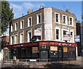
The Victory pub (site of) 264, Rotherhithe New Road, London, SE16
At the junction with Galleywall Road (left) and first recorded in 1865. I do not know when the name changed to "The Golden Lion" and I do not understand why. As may be seen it is now up for sale and according to E-bay the starting price is £990,000.
Image: © Chris Lordan
Taken: 12 Oct 2009
0.01 miles
3
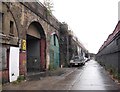
Jarrow Road. Rotherhithe, London, SE16
Off Rotherhithe New Road and about 50 yards west of Corbetts Passage. In the 1960's to 1980's and long before that, it was only known by locals as "Bogs Ole". It consisted totally of businesses within railway arches that then connected Rotherhithe New Road to Silwood Street. At least two arches contained nothing other than bones - imagine the smell! The arch far left was the Halfway House pub. The arches were and are, part of the 878 built 1832ish to carry rail lines from London to Greenwich.
Image: © Chris Lordan
Taken: 21 Oct 2009
0.04 miles
4
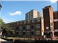
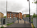
Barlow House
One of several similar housing blocks comprising the Rennie Estate. This one faces Galleywall Road. See Image for some history including an explanation of the name.
Image: © Stephen Craven
Taken: 21 May 2011
0.05 miles
5
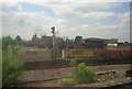
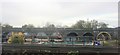
Viaducts and scrap-yards, Bermondsey
North of New Cross, various railway lines converge on London Bridge, all on viaducts. Between them, until the latter half of the twentieth century, other lines dropped to ground level to reach the Surrey Commercial Docks to the east, or Bricklayers Arms goods station to the west. Amongst this tangle of viaducts and disused lines there is now a complex area of scrap yards, industrial estates and waste disposal sites. From rail level one sees tantalising glimpses of this nether world but, of course, one is almost always in motion and thus a crisp photograph is difficult.
Image: © Christopher Hilton
Taken: 19 May 2011
0.06 miles
6
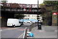
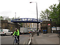
Bridge Over Rotherhithe New Road
This disused railway bridge carried the Bricklayers Arms branch of the South Eastern Railway across the road. Bricklayers Arms was one of the largest engine shed and goods yard facilities in London, covering 26 acres of land. The line was constructed in 1833-34 and remained in use until 1981 when the goods yards finally closed. The bridge remains in place but the extensive yards and shed areas have been redeveloped into housing estates. On the right, the station sign for South Bermondsey indicates footpath access to the station.
Subsequent to this photograph,in January 2013 this old railway bridge was replaced by a new shared use (cycle and pedestrian) bridge giving easy access to the station from a nearby housing estate. Stephen Craven's Image shows the new bridge.
Image: © Martin Addison
Taken: 22 Oct 2010
0.06 miles
7
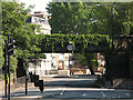
Disused railway bridge over Rotherhithe New Road
Viewed from the junction with Ilderton Road. See Image for some history. The bridge is currently (2011) earmarked for re-use as part of Sustrans's "Connect 2" project to provide a traffic-free cycle route over this busy main road.
Image: © Stephen Craven
Taken: 21 May 2011
0.07 miles
8
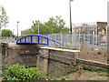
Bermondsey Connect2 bridge - east side
The 4 metre width new pedestrian and cycle bridge is narrower than the abutments of the old railway bridge that it replaced.
Image: © Stephen Craven
Taken: 9 May 2013
0.07 miles
9
Bermondsey Connect2 bridge - on top
Looking across the bridge from the south-east side. The generous 4 metre width is adequate for shared use.
Image: © Stephen Craven
Taken: 9 May 2013
0.07 miles
10
Bermondsey Connect2 bridge - west side
Looking along Rotherhithe New Road, the new bridge spans between the abutments of a former railway bridge Image
Image: © Stephen Craven
Taken: 9 May 2013
0.07 miles