IMAGES TAKEN NEAR TO
Stevenson Crescent, LONDON, SE16 3EN
Introduction
This page details the photographs taken nearby to Stevenson Crescent, SE16 3EN by members of the Geograph project.
The Geograph project started in 2005 with the aim of publishing, organising and preserving representative images for every square kilometre of Great Britain, Ireland and the Isle of Man.

There are currently over 7.5m images from over14,400 individuals and you can help contribute to the project by visiting https://www.geograph.org.uk
Image Map
Images are licensed for reuse under creativecommons.org/licenses/by-sa/2.0
Notes
- Clicking on the map will re-center to the selected point.
- The higher the marker number, the further away the image location is from the centre of the postcode.
Image Listing (68 Images Found)
Images are licensed for reuse under creativecommons.org/licenses/by-sa/2.0
Image
Details
Distance
1
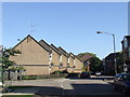
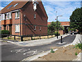
Stevenson Crescent, SE16
Houses on Stevenson Crescent, SE16. This land had previously been the route of the railway to Bricklayer's Arms goods depot.
Image: © Malc McDonald
Taken: 10 Oct 2010
0.04 miles
2
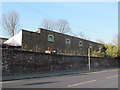
Old Southern Railway stables (2)
Nearly all of the former, extensive Bricklayers Arms goods depot has long since been redeveloped for houses. Only these stable buildings remain from the original railway site. As of 2015 they were still in light industrial use. Surprisingly they are not listed, giving them no protection against future redevelopment. See also Image
Image: © Stephen Craven
Taken: 14 Apr 2015
0.04 miles
3
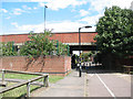
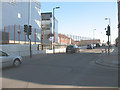
St James's Road bridge
The bridge formerly crossed a railway line, but the railway land has been developed for housing since it closed in 1981 and the transport route under the bridge is now simply a cycle path linking Abercorn Way and Stevenson Crescent.
Image: © Stephen Craven
Taken: 18 Jul 2009
0.06 miles
4
Old Southern Railway stables (1)
Nearly all of the former, extensive Bricklayers Arms goods depot has long since been redeveloped for houses. Only these stable buildings remain from the original railway site. As of 2015 they were still in light industrial use. Surprisingly they are not listed, giving them no protection against future redevelopment. See also Image
Image: © Stephen Craven
Taken: 14 Apr 2015
0.06 miles
5
Quietway improvements (3)
Where Abercorn Way meets Stevenson Crescent under the St James's Road bridge, the former cycle barrier Image was replaced around April 2015 with a wider gap to allow cyclists through at higher speeds and minimal bollards to keep motor vehicles out, and more signage to indicate that it is part of the London Cycle Network (and the new "quietway" from Waterloo to Greenwich).
The bridge formerly crossed a railway line, but the railway land has been developed for housing since it closed in 1981.
Image: © Stephen Craven
Taken: 10 Jul 2015
0.07 miles
6
Catlin Street cycle crossing
In April 2013, improvements were made to London Cycle Network route 2 in the South Bermondsey area, including moving the crossing point of Catlin Street about ten metres further west to opposite the entrance to Stevenson Close. From a cyclist’s point of view, this had the disadvantage of taking one away from where there was a clear view of traffic turning into Catlin Street, thereby adding some risk to what had been a very safe crossing point.
Image: © Stephen Craven
Taken: 17 Jul 2013
0.08 miles
7
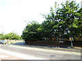
Stevenson Crescent, South Bermondsey
The Crescent is one of several residential streets occupying former railway land. This photo is of a spur at its northern end that becomes a cycle path linking to Lynton Road.
Image: © Stephen Craven
Taken: 19 Aug 2009
0.09 miles
8
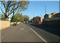
Rotherhithe New Road, SE16
Looking north east.
Image: © Philip Talmage
Taken: 18 Nov 2005
0.10 miles
9
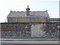
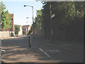
St James's Road, Bermondsey - bridge approach
The road rises at this point to the bridge over the route of former railway line - for a view of the bridge from the road underneath see Image The building at left is a school Image
Image: © Stephen Craven
Taken: 19 Aug 2009
0.10 miles
10
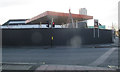
Closed Total garage, St James's Road, Bermondsey
The canopy of the petrol station was still intact at this point, but there appears to be a borehole rig on site behind the hoarding, so no doubt a new development was due to appear before long.
Image: © Stephen Craven
Taken: 14 Apr 2015
0.10 miles